During the lengthy glacial periods, with so much
of the earth's water locked up in ice, sea level was
low -- more than 100 meters lower -- exposing huge
treks of land i.e. the continental shelves. This allowed
easy movement between the continents, connecting
what was otherwise islands & allowing gene flow
between all the widely dispersed groups. But when
sea level rose again, during the much briefer
interglacials, drowning these transcontinental highways,
movement was restricted. They couldn't always push
along to a new stretch of beach. So they either had to
push inland or, now get this, learn to get more out of
any given stretch of beach. And they could do that by
diving.
Eh? A rise in sea level from a glacial low
creates more beach, on average, not less,
J. J. Lodder wrote:
Eh? A rise in sea level from a glacial low
creates more beach, on average, not less,
Please, oh PLEASE tell me you recently suffered a traumatic
brain injury!
J. J. Lodder wrote:
Eh? A rise in sea level from a glacial low
creates more beach, on average, not less,
Please, oh PLEASE tell me you recently suffered a traumatic
brain injury!
On Sun, 1 Jan 2023 10:20:59 -0800 (PST), JTEM wrote:
J. J. Lodder wrote:
Eh? A rise in sea level from a glacial low
creates more beach, on average, not less,
Please, oh PLEASE tell me you recently suffered a traumatic
brain injury!
Beaches occur where shorelines exist around gradual elevation changes.
By logic and by observation, gradual elevation changes occur where
landscapes have been exposed to wind and running water, which erode
more the higher elevations and fill in more the lower elevations,
averaging them out and approaching sea level. Since falling sea
levels necessarily expose previously unexposed land, and rising sea
levels necessarily submerge previously uncovered land, that means more beaches would be created during the latter process.
JTEM is my hero <jtem01@gmail.com> wrote:
J. J. Lodder wrote:
Eh? A rise in sea level from a glacial low
creates more beach, on average, not less,
Please, oh PLEASE tell me you recently suffered a traumatic
brain injury!
Many thanks for your best wishes for the new year!
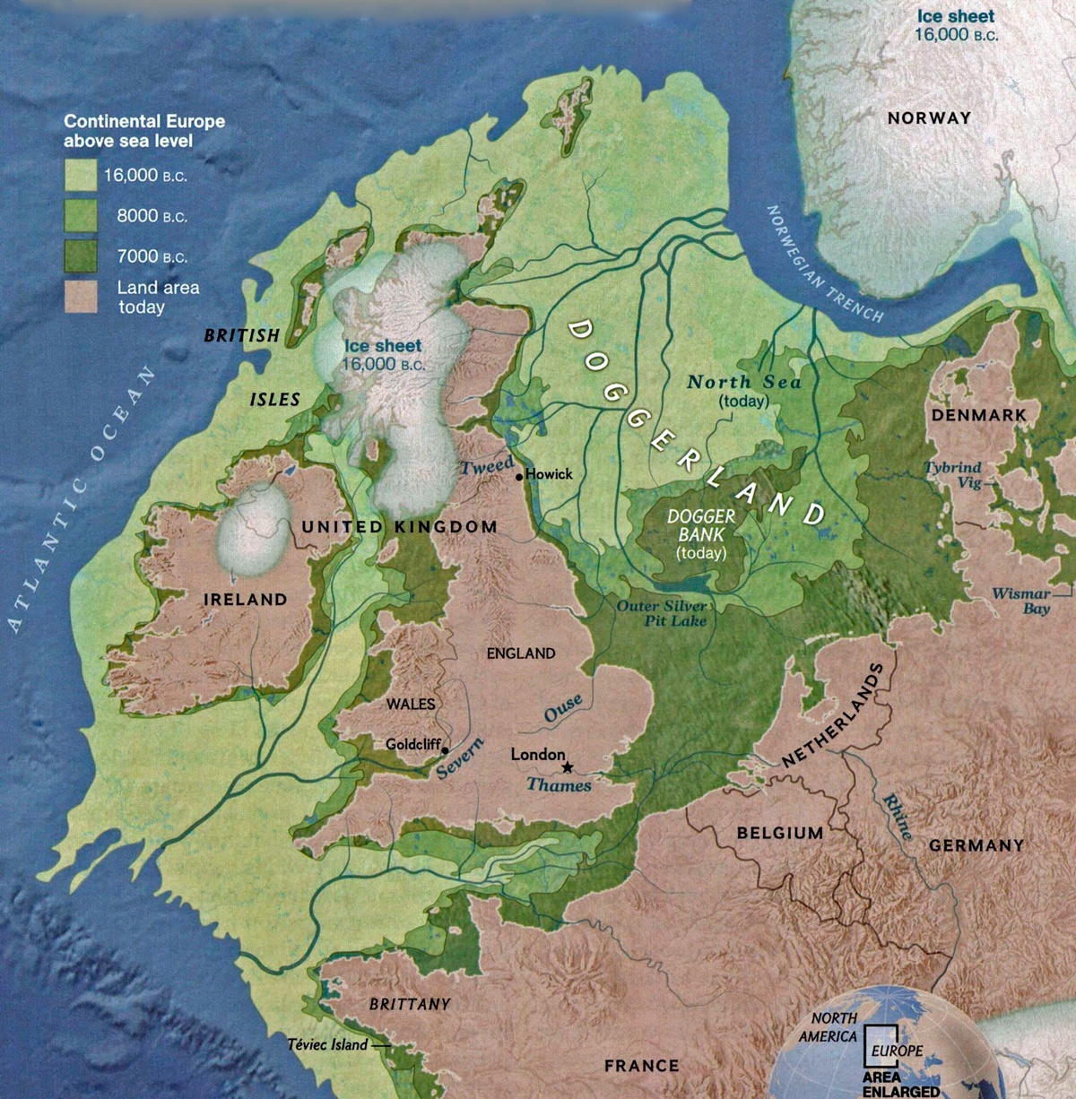
As for coastlines, you might wish to have a look at <http://stedmundsburychronicle.com/Chronicle/5mbp-700bcpics/doggerland18000ybp.jpg>
for example.
Your guess wich coastline is the longest,
Jan
JTEM is my hero <jte...@gmail.com> wrote:
J. J. Lodder wrote:
Eh? A rise in sea level from a glacial low
creates more beach, on average, not less,
Please, oh PLEASE tell me you recently suffered a traumatic
brain injury!
Many thanks for your best wishes for the new year!
As for coastlines, you might wish to have a look at <http://stedmundsburychronicle.com/Chronicle/5mbp-700bcpics/doggerland18000ybp.jpg>
for example.
Your guess wich coastline is the longest,
That's what passes for Christian charity for many people who call
themselves Christians today.
On 1/2/23 7:26 AM, jillery wrote:
On Sun, 1 Jan 2023 10:20:59 -0800 (PST), JTEM wrote:
J. J. Lodder wrote:
Eh? A rise in sea level from a glacial low
creates more beach, on average, not less,
Please, oh PLEASE tell me you recently suffered a traumatic
brain injury!
Beaches occur where shorelines exist around gradual elevation changes.
By logic and by observation, gradual elevation changes occur where
landscapes have been exposed to wind and running water, which erode
more the higher elevations and fill in more the lower elevations,
averaging them out and approaching sea level. Since falling sea
levels necessarily expose previously unexposed land, and rising sea
levels necessarily submerge previously uncovered land, that means more
beaches would be created during the latter process.
Seems to me it means just the opposite. Rising seas usually result in
less seashore.
Consider a single island (conveniently, it is rectangular). The numbers >indicate height above sea level; '0' is ocean:
0111111110
0122222210
0123333210
0122222210
0111111110
Then the sea rises one unit. Now the island looks like this:
0000000000
0011111100
0012222100
0011111100
0000000000
The latter island has less beach.
J. J. Lodder wrote:bp.jpg>
JTEM is my hero <jte...@gmail.com> wrote:
J. J. Lodder wrote:
Eh? A rise in sea level from a glacial low
creates more beach, on average, not less,
Please, oh PLEASE tell me you recently suffered a traumatic
brain injury!
Many thanks for your best wishes for the new year!
As for coastlines, you might wish to have a look at <http://stedmundsburychronicle.com/Chronicle/5mbp-700bcpics/doggerland18000y
for example.
That's a glacial _High_.
"Glacial Maximum."
J. J. Lodder wrote:
JTEM wrote:
J. J. Lodder wrote:
Eh? A rise in sea level from a glacial low
creates more beach, on average, not less,
Please, oh PLEASE tell me you recently suffered a traumatic
brain injury!
Many thanks for your best wishes for the new year!
As for coastlines, you might wish to have a look at
<http://stedmundsburychronicle.com/Chronicle/5mbp-700bcpics/doggerland18000ybp.jpg>
for example.
That's a glacial _High_.
"Glacial Maximum."
Your guess wich coastline is the longest,
Secondly, Homo was a tropical into sub tropical species. You had
to get a long ways into human evolution before they could ever
play THAT far north!
In other words, you're looking closer to the end point, not the
beginning... not the origins.
The point you raised here is about beaches, not origins.
Yes, Glacial high is sea level low.
Thanks for sharing this great insight with us,
On Mon, 2 Jan 2023 08:12:40 -0800, Mark Isaak
<specimen@curioustaxonomy.net> wrote:
On 1/2/23 7:26 AM, jillery wrote:
On Sun, 1 Jan 2023 10:20:59 -0800 (PST), JTEM wrote:
J. J. Lodder wrote:
Eh? A rise in sea level from a glacial low
creates more beach, on average, not less,
Please, oh PLEASE tell me you recently suffered a traumatic
brain injury!
Beaches occur where shorelines exist around gradual elevation changes.
By logic and by observation, gradual elevation changes occur where
landscapes have been exposed to wind and running water, which erode
more the higher elevations and fill in more the lower elevations,
averaging them out and approaching sea level. Since falling sea
levels necessarily expose previously unexposed land, and rising sea
levels necessarily submerge previously uncovered land, that means more
beaches would be created during the latter process.
Seems to me it means just the opposite. Rising seas usually result in
less seashore.
Consider a single island (conveniently, it is rectangular). The numbers
indicate height above sea level; '0' is ocean:
0111111110
0122222210
0123333210
0122222210
0111111110
Then the sea rises one unit. Now the island looks like this:
0000000000
0011111100
0012222100
0011111100
0000000000
The latter island has less beach.
Your model is of a land mass with relatively steep slopes. Also, the
total area in both of your maps are the same, when the total area in
the second map should be smaller; any unit less than 0 is underwater
due to sealevel rise.
Assume for simplicity that beaches are 0, and underwater is * (this
helps to keep the columns aligned). So your second map should look
like this:
*00000000*
*01111110*
*01222210*
*01111110*
*00000000*
So your before land mass has a beach area of 10, and a total area of
50, while your after land mass has a beach area of 22, and a total
area of 40.
So yes, in your specific example, the beach area increases both by
absolute count and by percentage. However, really small land masses
magnify the percentage, where only beach might be left. For
discussion purposes, only land masses large enough to minimize this complication should be considered.
Using your methodology, the following models a land mass with more
gradual slopes due to erosion and deposition, typical of continental
areas with little tectonic activity:
(before)
01111111111111111110
01111111122211111110
01111111222221111110
01111112233322111110
01111122334332211110
01111122334332211110
01111112233322111110
01111111222221111110
01111111122211111110
01111111111111111110
(after)
*000000000000000000*
*000000001110000000*
*000000011111000000*
*000000112221100000*
*000001122322110000*
*000001122322110000*
*000000112221100000*
*000000011111000000*
*000000001110000000*
*000000000000000000*
My before land mass has a beach area of 20, and a total area of 200,
while my after land mass has a beach area of 125, and a total area of
180. This is an increase of 59%. Compare this to your steeper sloped model's increase of 35%.
So at a first approximation, the amount of new beach depends on the
slope of the land, which is my point. It's proportional to either the slope's tangent or arc-tangent, but I'm too tired at the moment to
figure out which one.
jillery wrote:
The point you raised here is about beaches, not origins.
: During the lengthy glacial periods, with so much
: of the earth's water locked up in ice, sea level was
: low -- more than 100 meters lower -- exposing huge
: treks of land i.e. the continental shelves. This allowed
: easy movement between the continents, connecting
: what was otherwise islands & allowing gene flow
: between all the widely dispersed groups.
Now that you proved your utter lack of reading comprehension...
On 1/3/23 1:46 AM, jillery wrote:
On Mon, 2 Jan 2023 08:12:40 -0800, Mark Isaak
<specimen@curioustaxonomy.net> wrote:
On 1/2/23 7:26 AM, jillery wrote:
On Sun, 1 Jan 2023 10:20:59 -0800 (PST), JTEM wrote:
J. J. Lodder wrote:
Eh? A rise in sea level from a glacial low
creates more beach, on average, not less,
Please, oh PLEASE tell me you recently suffered a traumatic
brain injury!
Beaches occur where shorelines exist around gradual elevation changes. >>>> By logic and by observation, gradual elevation changes occur where
landscapes have been exposed to wind and running water, which erode
more the higher elevations and fill in more the lower elevations,
averaging them out and approaching sea level. Since falling sea
levels necessarily expose previously unexposed land, and rising sea
levels necessarily submerge previously uncovered land, that means more >>>> beaches would be created during the latter process.
Seems to me it means just the opposite. Rising seas usually result in
less seashore.
Consider a single island (conveniently, it is rectangular). The numbers >>> indicate height above sea level; '0' is ocean:
0111111110
0122222210
0123333210
0122222210
0111111110
Then the sea rises one unit. Now the island looks like this:
0000000000
0011111100
0012222100
0011111100
0000000000
The latter island has less beach.
Your model is of a land mass with relatively steep slopes. Also, the
total area in both of your maps are the same, when the total area in
the second map should be smaller; any unit less than 0 is underwater
due to sealevel rise.
You misunderstood my notation. '0' is ocean, so total land area in the >first picture is 40; in the second, 18. Perimeter (beach, measured >linearly) in the first is 26; in the second, 18.
Assume for simplicity that beaches are 0, and underwater is * (this
helps to keep the columns aligned). So your second map should look
like this:
*00000000*
*01111110*
*01222210*
*01111110*
*00000000*
So your before land mass has a beach area of 10, and a total area of
50, while your after land mass has a beach area of 22, and a total
area of 40.
So yes, in your specific example, the beach area increases both by
absolute count and by percentage. However, really small land masses
magnify the percentage, where only beach might be left. For
discussion purposes, only land masses large enough to minimize this
complication should be considered.
I grant that rising seas *might* increase percentage of beach, but since >some lands will be completely submerged, I have doubts that is in fact
the case. Anyway, I was addressing only the absolute amount.
Using your methodology, the following models a land mass with more
gradual slopes due to erosion and deposition, typical of continental
areas with little tectonic activity:
(before)
01111111111111111110
01111111122211111110
01111111222221111110
01111112233322111110
01111122334332211110
01111122334332211110
01111112233322111110
01111111222221111110
01111111122211111110
01111111111111111110
(after)
*000000000000000000*
*000000001110000000*
*000000011111000000*
*000000112221100000*
*000001122322110000*
*000001122322110000*
*000000112221100000*
*000000011111000000*
*000000001110000000*
*000000000000000000*
My before land mass has a beach area of 20, and a total area of 200,
while my after land mass has a beach area of 125, and a total area of
180. This is an increase of 59%. Compare this to your steeper sloped
model's increase of 35%.
So at a first approximation, the amount of new beach depends on the
slope of the land, which is my point. It's proportional to either the
slope's tangent or arc-tangent, but I'm too tired at the moment to
figure out which one.
The example I gave (as I intended it, anyway), shows constant rise,
which I grant is artificial. Yours, however, shows a very narrow >beach-level area, then a steep rise to a large level plateau above the >beach, then fairly steep hills. A more realistic topo-map showing
gradual ascent from sea level would look like this (using your notation,
and showing only the top left quarter of it):
************ (before)
*****0000000
**0000000000
**0000000000
**0001111111
*00011111111
*00011122222 ...
*00011222222
*00011222333
*00011223333
*00011223344
*00011223345
************ (after)
************
************
************
*****0000000
****00000000
****00011111 ...
****00111111
****00111222
****00112222
****00112233
****00112234
before, beach = 51; after, beach = 28 (times 4 to get the whole island).
You are correct that amount of beach affected depends on slope, but the
more realistic condition (less slope closer to sea level) means that as
sea level rises, the new beach will be steeper and therefore narrower
than the beach that was covered.
Even more important, the perimeter of
land *always* becomes less when sea level rises, regardless of slope
(unless cliffs are overhanging the sea, which is rare enough to disregard).
On 1/2/23 7:26 AM, jillery wrote:
On Sun, 1 Jan 2023 10:20:59 -0800 (PST), JTEM wrote:
J. J. Lodder wrote:
Eh? A rise in sea level from a glacial low
creates more beach, on average, not less,
Please, oh PLEASE tell me you recently suffered a traumatic
brain injury!
Beaches occur where shorelines exist around gradual elevation changes.
By logic and by observation, gradual elevation changes occur where
landscapes have been exposed to wind and running water, which erode
more the higher elevations and fill in more the lower elevations,
averaging them out and approaching sea level. Since falling sea
levels necessarily expose previously unexposed land, and rising sea
levels necessarily submerge previously uncovered land, that means more
beaches would be created during the latter process.
Seems to me it means just the opposite. Rising seas usually result in
less seashore.
Consider a single island (conveniently, it is rectangular). The numbers indicate height above sea level; '0' is ocean:
0111111110
0122222210
0123333210
0122222210
0111111110
Then the sea rises one unit. Now the island looks like this:
0000000000
0011111100
0012222100
0011111100
0000000000
The latter island has less beach.
On 02/01/2023 16:12, Mark Isaak wrote:
On 1/2/23 7:26 AM, jillery wrote:
On Sun, 1 Jan 2023 10:20:59 -0800 (PST), JTEM wrote:
J. J. Lodder wrote:
Eh? A rise in sea level from a glacial low
creates more beach, on average, not less,
Please, oh PLEASE tell me you recently suffered a traumatic
brain injury!
Beaches occur where shorelines exist around gradual elevation changes.
By logic and by observation, gradual elevation changes occur where
landscapes have been exposed to wind and running water, which erode
more the higher elevations and fill in more the lower elevations,
averaging them out and approaching sea level.� Since falling sea
levels necessarily expose previously unexposed land, and rising sea
levels necessarily submerge previously uncovered land, that means more
beaches would be created during the latter process.
Seems to me it means just the opposite.� Rising seas usually result in
less seashore.
Consider a single island (conveniently, it is rectangular).� The numbers
indicate height above sea level; '0' is ocean:
0111111110
0122222210
0123333210
0122222210
0111111110
Then the sea rises one unit.� Now the island looks like this:
0000000000
0011111100
0012222100
0011111100
0000000000
The latter island has less beach.
The first approximation is that shoreline is proportional to land area,
which would imply that the amount of beaches is greater during glacial >periods. But the length of the shoreline also depends on the roughness
of the topography at the level of the sea surface.
J. J. Lodder proffered a map of Europe showing less shoreline during >glaciations - no Baltic coasts, drastically reduced North Sea coasts,
etc. One could also look at Sunda and Sahul during glacial periods, or
the Persian Gulf.
But other parts of the world show changes in the reverse direction. The >Mascarenes and Seychelles area have a lot more land, and more shoreline,
so I guess one what actually have to add up the changes, rather than
declare an answer from first principles. (Though the Mascarenes and >Seychelles don't help with the claim that there was more shoreline
available for human habitation during glacial periods.)
For continents flooding of river valleys cut during sea level lowstands
(and glacial valleys) increases the length of shorelines. But there is a >possibility that maps of glacial shorelines exaggerate their smoothness,
due to lack of knowledge of the details of their positions.
Really? Odd that your copied text makes no mention of origins.
Meanwhile, you conveniently forgot to copy this bit from the very same
OP you copied above:
********************************
They couldn't always push
along to a new stretch of BEACH. So they either had to
push inland or, now get this, learn to get more out of
any given stretch of BEACH.
, jillery wrote:
Really? Odd that your copied text makes no mention of origins.
Oh. So you're on the spectrum. Why didn't you just say so? Autism
doesn't carry the stigma it once held...
Meanwhile, you conveniently forgot to copy this bit from the very same
OP you copied above:
********************************
They couldn't always push
along to a new stretch of BEACH. So they either had to
push inland or, now get this, learn to get more out of
any given stretch of BEACH.
Yeah. This is knows by an obscure technical term called "Eating."
They ate. Big whoop.
They ate. Big whoop.
It's your point.
jillery wrote:
They ate. Big whoop.
It's your point.
Is that why you've got this hair across your ass? Because I said that
they ate?
Nope. Your
jillery wrote:
Nope. Your
A lack of reading comprehension does not an argument make.
Again:
: During the lengthy glacial periods, with so much
: of the earth's water locked up in ice, sea level was
: low -- more than 100 meters lower -- exposing huge
: treks of land i.e. the continental shelves. This allowed
: easy movement between the continents, connecting
: what was otherwise islands & allowing gene flow
: between all the widely dispersed groups.
But when********************************************
sea level rose again, during the much briefer
interglacials, drowning these transcontinental highways,
movement was restricted. They couldn't always push
along to a new stretch of BEACH. So they either had to
push inland or, now get this, learn to get more out of
any given stretch of BEACH. And they could do that by
diving.
There you go. That's the model. Eating along the water's edge
isn't enough, because that alone doesn't move you
everywhere from Oceania to southern Africa.
Neither does conveniently forgetting what you wrote:
Again:
: During the lengthy glacial periods, with so much
: of the earth's water locked up in ice, sea level was
: low -- more than 100 meters lower -- exposing huge
: treks of land i.e. the continental shelves. This allowed
: easy movement between the continents, connecting
: what was otherwise islands & allowing gene flow
: between all the widely dispersed groups.
Again, the above is transparent evasion: *****************************************
But when
sea level rose again, during the much briefer
interglacials, drowning these transcontinental highways,
movement was restricted. They couldn't always push
along to a new stretch of BEACH.
So they either had to
push inland or, now get this, learn to get more out of
any given stretch of BEACH. And they could do that by
diving.
There you go. That's the model. Eating along the water's edge
isn't enough, because that alone doesn't move you
everywhere from Oceania to southern Africa.
You don't read maps any better than you read your own posts.
Pick your battles more carefully, honey drops.
You
| Sysop: | Keyop |
|---|---|
| Location: | Huddersfield, West Yorkshire, UK |
| Users: | 300 |
| Nodes: | 16 (0 / 16) |
| Uptime: | 115:38:38 |
| Calls: | 6,701 |
| Calls today: | 1 |
| Files: | 12,235 |
| Messages: | 5,349,126 |