Is there a way to put the gps coordinates onto a photo?
Is there a way to put the gps coordinates onto a photo?
Is there a way to put the gps coordinates onto a photo?
I have Windows 10 and Android 11.
I am working on a project with multiple very large apartment complexes.
I have a paper colored apartment complex map for each complex.
The map does not seem to be online so it's a paper handout.
At each complex I'm expected to visit a set of given units each day for various reasons and all they give me is this paper map to find each unit.
That works. But it's inefficient.
They do this to everyone, not just to me.
We're expected to use the paper map with hundreds of apartments and dozens
of buildings, where the numbering system for buildings usually makes sense but not for the apartments. Sometimes we even need to visit parking spaces
as we have vehicles parked which we have to put notices on where the
numbers make no sense on purpose for security reasons.
Once I find a given location, I've been using OSMand+ to save the current position. First off I'm surprised that OSMAnd+ doesn't have a "Save Current Location" option which I thought almost all map programs would have had.
These apartments all have individual outside entrances so it's not like a hotel where you go down a long hallway to serially find the door number you need.
So what I do is establish my current location & long press the blue dot.
When I get to the right apartment door I step outside the entrance on the ground floor and press as close as I can on the blue location dot which
pops up a "Looking up address" OSMAnd+ menu which usually gives the same address for all locations. Then I press the "Add" star and change the name
to "Complex Bathroom" or "Complex Pool" or more commonly "ComplexBldgApt" such as "RedwoodApts Bldg15 Apt489" or "RedwoodApts Lot15 Spot489" or something like that.
Once I've renamed the current pressed location, I hit Save and then I can navigate walking after that where OSM can talk me through the steps even
when the phone is in my pocket and my hands are full.
Having to fatfinger the location isn't as accurate as having a "Save
Current Location" button would be but it's definitely good enough for government work as they say.
When I need to navigate to a given spot I first point the phone north with
a compass app because moving compass navigation directions aren't so easy when walking and then I orient the OSM map toward that heading to get my initial bearings of which way to start walking and about how far it will
be. Usually I'm carrying tools or supplies so my hands are almost always full.
That's all I need but I'm working with others from the local work to future group where everyone else wastes time trying to find the building & apt.
What I want is take a jpeg picture of the paper colored apartment complex
map which I can then hand to each person whose phone can then point to the location.
All of that brings me to my question of how to make that jpeg gps map.
Is there a way to put the gps coordinates onto a photo?
Is there a way to put the gps coordinates onto a photo?
I don't know if a georeferencing program exists on Windows or on Android
for jpeg files but what you need for your jpeg is similar to what common georeferencing software does for a PDF to establish the coordinates for
every point on the grid of the jpeg.
https://www.usgs.gov/faqs/what-geopdfr
Once you associate the coordinate grid onto that jpeg file, the map program will be able to navigate based on those reference points.
Those talking about exif data don't understand how navigation works.
It's common to georeference a PDF but a google search finds you can georeference an image also if you know what you're doing. https://mdl.library.utoronto.ca/technology/tutorials/how-georeference-images-arcgis
curmudgeon <curmudgeon@spam.edu> wrote:[...]
looks like I need to find a program for Windows which will georeference[...]
the digital image
It's common to georeference a PDF but a google search finds you can
georeference an image also if you know what you're doing.
https://mdl.library.utoronto.ca/technology/tutorials/how-georeference-images-arcgis
It may be impossible to georeference the jpeg but I can convert it to a pdf using windows irfanview conversion plugins.
Is there a way to put the gps coordinates onto a photo?
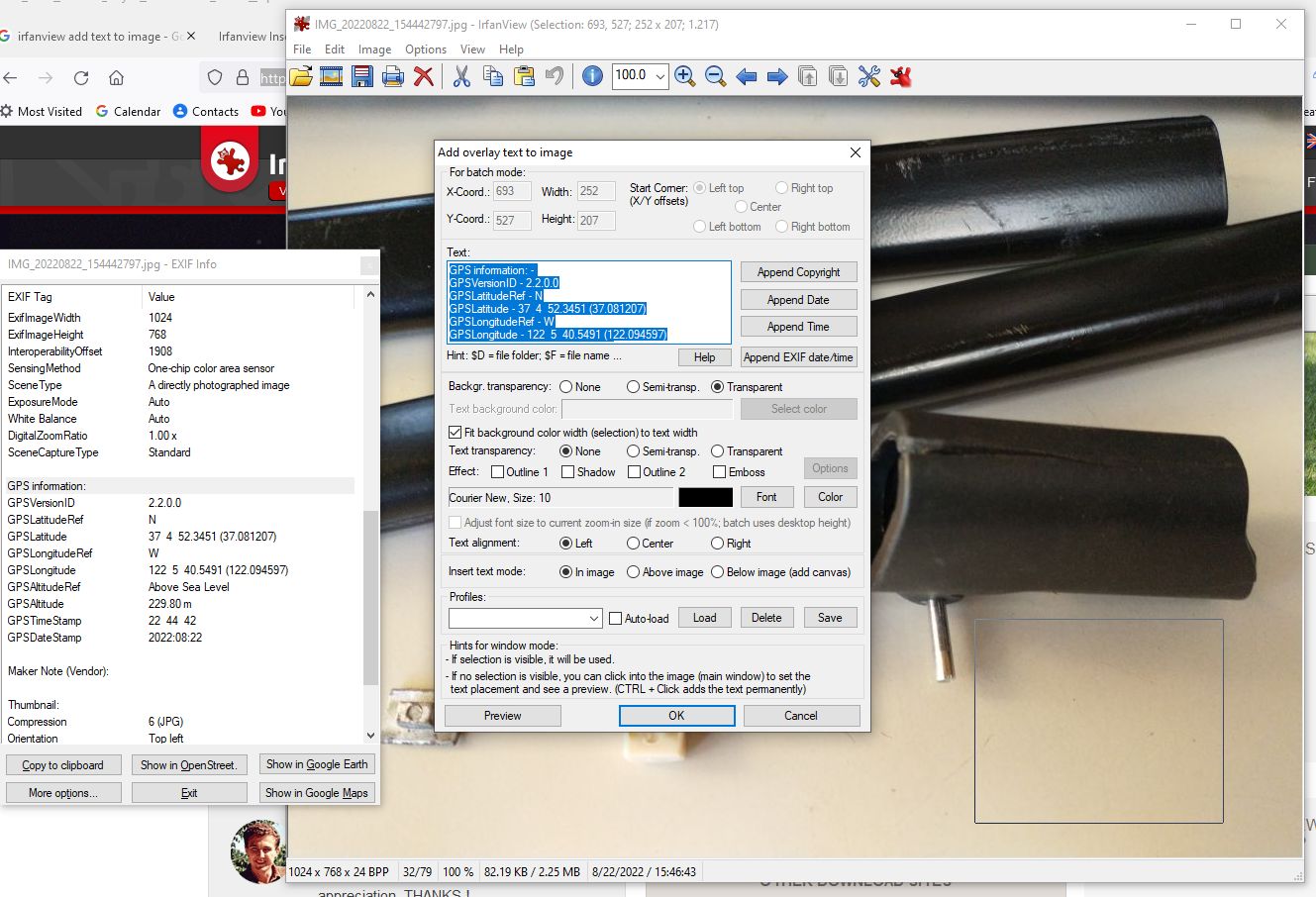
Will this work for you? <http://www.learnbydestroying.com/jeffl/crud/Irfanview%20Insert%20Text.jpg>
Install Irfanview viewer and plugs:
<https://www.irfanview.com>
Open a picture.
Hit "e" on the keyboard. That should bring up the EXIF data.
Highlight the EXIF data you want to insert using the mouse and the
shift or control key.
Right click the mouse and select "Copy selected lines to Clipboard" or
hit "alt-S"
Exit EXIF info window.
One the picture, use the mouse frame an area where you want the text
to appear.
On the menu line above the picture, select:
Edit -> Insert Text (ctrl-T)
Hit <ctrl-V> to paste the text from the clipboard into the Text box.
It should look something like this screen dump: <http://www.learnbydestroying.com/jeffl/crud/Ifranview%20Insert%20Text%20Screen.jpg>
Play with the options. Hit OK.
Save the picture and you're done.
take your camera and snap a photo of the coordinates on your GPS receiver.
Is there a way to put the gps coordinates onto a photo?
I have Windows 10 and Android 11.
I am working on a project with multiple very large apartment complexes.
I have a paper colored apartment complex map for each complex.
The map does not seem to be online so it's a paper handout.
At each complex I'm expected to visit a set of given units each day for various reasons and all they give me is this paper map to find each unit.
That works. But it's inefficient.
They do this to everyone, not just to me.
We're expected to use the paper map with hundreds of apartments and dozens
of buildings, where the numbering system for buildings usually makes sense but not for the apartments. Sometimes we even need to visit parking spaces
as we have vehicles parked which we have to put notices on where the
numbers make no sense on purpose for security reasons.
Once I find a given location, I've been using OSMand+ to save the current position. First off I'm surprised that OSMAnd+ doesn't have a "Save Current Location" option which I thought almost all map programs would have had.
These apartments all have individual outside entrances so it's not like a hotel where you go down a long hallway to serially find the door number you need.
So what I do is establish my current location & long press the blue dot.
When I get to the right apartment door I step outside the entrance on the ground floor and press as close as I can on the blue location dot which
pops up a "Looking up address" OSMAnd+ menu which usually gives the same address for all locations. Then I press the "Add" star and change the name
to "Complex Bathroom" or "Complex Pool" or more commonly "ComplexBldgApt" such as "RedwoodApts Bldg15 Apt489" or "RedwoodApts Lot15 Spot489" or something like that.
Once I've renamed the current pressed location, I hit Save and then I can navigate walking after that where OSM can talk me through the steps even
when the phone is in my pocket and my hands are full.
Having to fatfinger the location isn't as accurate as having a "Save
Current Location" button would be but it's definitely good enough for government work as they say.
When I need to navigate to a given spot I first point the phone north with
a compass app because moving compass navigation directions aren't so easy when walking and then I orient the OSM map toward that heading to get my initial bearings of which way to start walking and about how far it will
be. Usually I'm carrying tools or supplies so my hands are almost always full.
That's all I need but I'm working with others from the local work to future group where everyone else wastes time trying to find the building & apt.
What I want is take a jpeg picture of the paper colored apartment complex
map which I can then hand to each person whose phone can then point to the location.
All of that brings me to my question of how to make that jpeg gps map.
Is there a way to put the gps coordinates onto a photo?
But I'd use Adobe Acrobat since it's easy to edit the image as a PDF. https://acrobatusers.com/tutorials/how-create-geospatial-pdf/
Georeferencing images predates georeferencing of *.pdf files by decades.
An excellent free GIS program for Windows (and other operating systems) capable of georeferencing is QGIS:
https://www.qgis.org
Here is a tutorial:
http://www.qgistutorials.com/en/docs/3/georeferencing_basics.html
But the op can download Google satellite image map tiles & OSM map tiles. https://github.com/AliFlux/MapTilesDownloader
I would think those tiles would come with the georeferences already.
But I found a way to download the apartment OSM map tile as an osm file. https://blog.richmond.edu/sal/2017/10/30/downloading-open-street-map-osm-data/
From Windows you use the OSM web interface to export *.osm tiles. https://www.openstreetmap.org/export#map=18/{latitude}/{longitude}
Then I converted that exported *.osm file to a series of SHP files. http://mygeodata.cloud/
If anyone knows what to do next, please let me know.
But I found a portable GIS version 6 that installs onto a removable drive. https://portablegis.xyz/
https://download.astuntechnology.com/home/ (login=pgis,password=pgis) https://download.astuntechnology.com/home/portablegis_setup_v60.exe
Do you think the tutorial will work with pgis instead?
But I think it maybe needs the Acrobat Writer and not the Acrobat Reader. https://acrobatusers.com/tutorials/acrobat-and-reader-9-and-geospatial/
Does anyone know if the reader can create the geospatial PDFs?
Or just the writer?
It won't be as simple to set up as you might like it to be though as
Portable GIS has a dependency on C++ and JOSM has a dependency on Java.
The main problem with QGIS is it won't work with the HP Stream 11 laptop.
I found a portable GIS version 6 that installs onto a removable drive[...]
Do you think the tutorial will work with pgis instead?
I wasn't able to get that OSM tile downloader to work on Windows 10.
If you get QGIS up and running, you can embed OSM inside your maps and
export OSM data to other formats, like shapefiles.
What I need is a TEXT (not video!) tutorial for QGIS 3.4 that shows how to georeference a PDF or JPEG
I am stuck at what I save and what I load into an Android map program.
The QGIS interface is so complex that I need to look for a newer tutorial.
I wasn't able to get that OSM tile downloader to work on Windows 10.
If you get QGIS up and running, you can embed OSM inside your maps and
export OSM data to other formats, like shapefiles.
This "laptop" has less system resources than most smartphones.
It runs Windows in a protected (app-only) S mode.
QGIS, OTOH, is a desktop program.
You should be able to switch Windows from S-Mode to normal mode without additional costs. But beware, you are /not/ able to reverse this decision!
In normal Windows mode, some system protections are switched off, which
leads to this "laptop" being not eligible for certain usage scenarios, anymore, like using it in educational exams.
https://support.microsoft.com/en-us/windows/switching-out-of-s-mode-in-windows-4f56d9be-99ec-6983-119f-031bfb28a307
Be this as it may: The "laptop" in addition does not meet QGIS minimum
system requirements for RAM and the like. It /may/ be possible to install
and use QGIS, nevertheless. But /if/ it does work, everything will be painfully slow. (GIS software is usually a domain of workstations and
not mere pocket calculators...)
I found a portable GIS version 6 that installs onto a removable drive[...]
Do you think the tutorial will work with pgis instead?
Why not? Portable GIS just copies a normal QGIS installation folder (and
a lot more programs, you don't actually need for georeferencing images)
and adjusts some path entries and the like.
What I need is a TEXT (not video!) tutorial for QGIS 3.4 that shows how to >> georeference a PDF or JPEG
I linked you to one a week ago:
Message-ID: <1us8biu0iol71.dlg@b.rose.tmpbox.news.arcor.de>
| http://www.qgistutorials.com/en/docs/3/georeferencing_basics.html
A couple of days later, curmudgeon linked you to an advanced one, which
you probably should omit first, until you understood the basics.
Message-ID: <tgovv3$113f$1@gioia.aioe.org> http://www.qgistutorials.com/en/docs/3/advanced_georeferencing.html
Having said this, your image needs most likely georeferencing methods
from the advanced portfolio. But without the basics you'll probably
get lost in the advanced tutorial.
It is important to emphasize, that ground control points should be
clearly positionable. If you are unsure, whether a coordinate of your
image /really/ is identical to a point of an already georeferenced
map layer, choose another one.
And try to wide-spread the ground
control points on the whole image. A couple of points with short
distances between each other will provide good coordinates just for
the included area. Everything outside will most likely deviate.
If the source image is not distorted, choose a simple transformation algorithm (like linear), if possible. Higher level algorithms try to
correct distortion and are most likely to insert a distortion not
present in the original image.
I am stuck at what I save and what I load into an Android map program.
You mentioned OSMAnd. This program will load points (for example a
point shape digitized on your georeferenced image) converted to Points
of Interest (POI). These can be selected as navigation target and can
carry a remarks field for additional information.
From your promiscuous OP I'm not sure, whether georeferencing really
/is/ the best approach for your needs.
You can add Open Street Map WMS layers to your map project:
https://wms.openstreetmap.de/wms?
and digitize your points on top of them as point shape or the like.
Or you can download parts of the OMS data for offline usage:
http://www.qgistutorials.com/en/docs/3/downloading_osm_data.html
Another way would be to create a map project with QGIS for use with
QField on a smartphone. Search for QField in the app store of your
smartphone or get binary packages from here:
https://github.com/opengisch/QField/releases
You can add map background data (OSM, aerials, topo maps, georeferenced images, shapefiles,...) and digitize the points directly in the field
by adding points either manually or per GPS. Later on, you can re-import
the point shape to QGIS and export them to POI's for OSMAnd and the like.
I was able to create shapefiles but I don't know what to do with them.[...]
If anyone knows what to do next, please let me know.
When I georeferenced it, the location was off by about 100 yards.
And I haven't been able to add the apartment complex POIs yet.
And nobody tells you that there's a trick to getting the georeference menu
to show up (I'm still not sure exactly what I did to make it show up).
I did something with the "Georeference GDAL" plugin and then I punched something else, and only after a while did the georeference menu show up (I wish people would put that stuff in their tutorials since you only have to
do it once - but if you don't know to do it - you don't get the menu).
But please don't blame me for badly written tutorials & installers.
I guess what you're saying, and if I guess wrong please correct me, I guess you're saying some points are less reliable than others. So a reliable
point, for example, might be the center of an intersection more so than the center of a pool. Is that what you're trying to warn me about?
I did try to pick a GCP on each corner of the apartment complex map and in the middle where the pool was, but what I can easily do is add a dozen GCPs since they're easily enough created.
My problem is what do I do AFTER I create the GCPs and run the georeference command on the suggested transformation and datum?
What format do I save map in that OSMAnd and/or Avenza will read and allow
me to navigate on? And how do I save the apartment numbers on the map so
that I can route to them on foot?
THANK YOU FOR THAT HINT. In the end I have to hand this map to other people who will be using OSMAnd or Avenza to navigate around the apartment
complex.
If I can find a tutorial that does exactly that, I will be golden!
I'm surprised that OSMAnd+ doesn't have a "Save Current Location" option
I meant to address this from the beginning and unfortunately forgot while reading through your very long OP:
I'm surprised that OSMAnd+ doesn't have a "Save Current Location" option
Point positions can be saved in OSMAnd as markers by long clicking on any point in the map:
https://osmand.net/docs/user/personal/markers
Zoom sufficiently deep into the map, beforehand, to ensure the required accuracy. Label name (= info) and style can be adjusted in the AddMarker dialog.
These markers can either be exported to a *.gpx file from MyPlaces menu: Click on the icon with 3 linked dots and choose a file manager like TotalCommander as target.
Alternatively, you can use Backup&Restore from the Settings menu. Select "local backup -> save as file". Then open the MyPlaces drop-down list and tick on Favorites. "Continue" and, again, select a file manager als target. Now the *.gpx file will be saved inside a *.zip-file named *.osf. (Rename
it to *.zip, if you want to access the content with any *.zip browser.) Alongside the *.gpx will be a *.json file with some additional info.
You have to check, whether my information for markers and favorites need
to be exchanged. (Especially wrt. exporting.) I use the German version of OSMAnd and there seem to be translation issues, mixing both point features up, sometimes...
Zoom sufficiently deep into the map, beforehand, to ensure the required
accuracy. Label name (= info) and style can be adjusted in the AddMarker
dialog.
As I said when I posted the flaw in OSMAnd that it can't save the current position, there are always these workaround kluges, which I've been using.
These markers can either be exported to a *.gpx file from MyPlaces menu:
Click on the icon with 3 linked dots and choose a file manager like
TotalCommander as target.
The flaw in OSMAnd is that you can't just save the current position.
You have to pick a point on the map. That's the flaw.
The current location saved is only as good as your fat finger is.
Other free nav programs have a menu selection to "Save Current Position."
Other free nav programs have a menu selection to "Save Current Position."
I, myself, would always prefer to manually set the marker on the map with
a sufficiently deep zoom level.
If the basis map is well enough, this
enables you to overcome uncertainties and inaccuracies from the current
GPS position by evaluating the position /and/ the map data against your
real surroundings. (The device running your OSMAnd will most likely have
just a consumer level GNSS with rather large average positioning error.)
Be this as it may: If you /really/ want the marker to be set on the current GPS position (provided, an active GPS position is acquired at that moment), you just need to long-press on the blue round GPS-center button on the
right bottom of the screen.
This opens the MyPosition dialog, which shows
info about the current position. Apart from this, there is a star-icon
in the menu of this dialog, which enables you to set a marker exactly on
the current GPS location.
Once I find a given location, I've been using OSMand+ to save the current position. First off I'm surprised that OSMAnd+ doesn't have a "Save Current Location" option which I thought almost all map programs would have had.
If you /really/ want the marker to be set on the current
GPS position (provided, an active GPS position is acquired at that moment), you just need to long-press on the blue round GPS-center button on the right bottom of the screen.
Bernd Rose <b.rose.tmpbox@arcor.de> wrote:[Long-press GPS-center button for MyPosition dialog with "add marker" menu]
That's EXACTLY what I was asking for!
How did you find it?
What I will do is try to follow that first tutorial you referenced (even though I think it's for an earlier version of QGIS) and I will write back with the end result.
| Sysop: | Keyop |
|---|---|
| Location: | Huddersfield, West Yorkshire, UK |
| Users: | 297 |
| Nodes: | 16 (0 / 16) |
| Uptime: | 125:00:40 |
| Calls: | 6,662 |
| Files: | 12,212 |
| Messages: | 5,334,849 |