• Re: GPS loggers for iPhone.

    From Sten deJoode@21:1/5 to Jolly Roger on Sat Feb 24 21:45:00 2024
    XPost: misc.phone.mobile.iphone

    On 22 Feb 2024 20:15:55 GMT, Jolly Roger wrote:

    I personally don't mind paying a reasonable price for an app but I
    despise (and won't) rent an app.

    Same here.

    I would pay for an app if there was no other app that did the job,
    but there's always a FOSS app that does the job just fine without paying.

    For example, these all allow an unlimited number of saved GPS tracks.
    Almost all are open source which is where I get almost all my apps from.

    FOSS GPS Logger by BasicAirData 4.3 star 2.37K reviews 100K+ Downloads free adfree
    https://play.google.com/store/apps/details?id=eu.basicairdata.graziano.gpslogger

    FOSS OpenTracks by Dennis Guse 4.0 star 53 reviews 500+ Downloads free adfree https://play.google.com/store/apps/details?id=de.dennisguse.opentracks.playstore
    https://f-droid.org/en/packages/de.dennisguse.opentracks/
    (it's payware on the google play store but open source freeware on F-Droid)

    GPSLogger II - AIO by Matthias Marquardt 4.3 star 127 reviews 10K+ Downloads free adfree
    https://play.google.com/store/apps/details?id=com.emacberry.gpslogger

    FOSS OSMTracker for Android by Laboratorio Experimental 3.8 star 228 reviews 50K+ Downloads free adfree
    https://play.google.com/store/apps/details?id=net.osmtracker

    Geo Tracker - GPS tracker by Ilya Bogdanovich 4.6 star 88K reviews 5M+ Downloads free adfree inapp purchases
    https://play.google.com/store/apps/details?id=com.ilyabogdanovich.geotracker

    --- SoupGate-Win32 v1.05
    * Origin: fsxNet Usenet Gateway (21:1/5)
  • From Sten deJoode@21:1/5 to All on Sat Feb 24 22:30:48 2024
    XPost: sci.geo.satellite-nav

    After I posted that, I ran a better search in the app finder for
    a. gps tracking apps
    b. that are free
    c. without ads
    d. and without in-app purchases

    Where >75 apps came up, many of which weren't in the prior list,
    so I went through the list to list a few others might like to try.

    FOSS GPS Logger by BasicAirData 4.3 star 2.37K reviews 100K+ Downloads free adfree
    https://play.google.com/store/apps/details?id=eu.basicairdata.graziano.gpslogger

    FOSS OpenTracks by Dennis Guse 4.0 star 53 reviews 500+ Downloads free adfree https://play.google.com/store/apps/details?id=de.dennisguse.opentracks.playstore
    https://f-droid.org/en/packages/de.dennisguse.opentracks/
    (it's payware on the google play store but open source freeware on F-Droid)

    GPSLogger II - AIO by Matthias Marquardt 4.3 star 127 reviews 10K+ Downloads free adfree
    https://play.google.com/store/apps/details?id=com.emacberry.gpslogger

    FOSS OSMTracker for Android by Laboratorio Experimental 3.8 star 228 reviews 50K+ Downloads free adfree
    https://play.google.com/store/apps/details?id=net.osmtracker

    Geo Tracker - GPS tracker by Ilya Bogdanovich 4.6 star 88K reviews 5M+ Downloads free adfree inapp purchases
    https://play.google.com/store/apps/details?id=com.ilyabogdanovich.geotracker

    GPSLogger A lightweight GPS logger, battery efficient, GPX/KML, add notes, share, upload.
    https://gpslogger.app/
    https://f-droid.org/en/packages/com.mendhak.gpslogger/ https://github.com/mendhak/gpslogger

    LD-Log Lite - GPS Logger by A.Wedemeyer - Outdoor & Sailing Apps 4.4 star 231 reviews 10K+ Downloads
    https://play.google.com/store/apps/details?id=com.aw.ldlogFree

    Wadlbeisser by Marco Pfattner 4.6 star 778 reviews 50K+ Downloads https://play.google.com/store/apps/details?id=de.pfattner.speedo.android

    Trailblazer by Andrew and Derek 4.7 star 7 reviews 100+ Downloads https://play.google.com/store/apps/details?id=com.andrewandderek.trailblazer

    GPSToolbox by Beijing Tele Industry Information Technology Ltd. 1K+ Downloads https://play.google.com/store/apps/details?id=net.gotele.gpsbox

    OSC - Hiking, Running, Cycling by Eliakim Schuenemann 1K+ Downloads https://play.google.com/store/apps/details?id=com.eschuenemann.outdoorsportscompanion

    Earth Explorer by software1001developer 50+ Downloads https://play.google.com/store/apps/details?id=com.earth.explorer

    Sondel-Buddy pro - Tool for m by Django's Android Apps 100+ Downloads https://play.google.com/store/apps/details?id=com.DjangoLaunchpad.Sondel_Buddy

    Here's a free ad free inapp free app for SPEAKING GPS directions (when walking).
    Trail Guide by Jordi Boixadera Planas 3.2 star 13 reviews 1K+ Downloads https://play.google.com/store/apps/details?id=com.jordiboixadera.trailGuide

    And here's a free ad free inapp free app for DRAWING & EDITING GPS tracks GPXLAB - The GPS Track Editor by LCX Ventures Ltd 4.1 star 8 reviews 100+ Downloads
    https://play.google.com/store/apps/details?id=com.lcxventures.gpxlab.app

    I've installed all of these and will test them out, but the nature of
    gps logging apps while in the field is that it will take me some time.

    --- SoupGate-Win32 v1.05
    * Origin: fsxNet Usenet Gateway (21:1/5)
  • From Bernd Rose@21:1/5 to Sten deJoode on Sun Feb 25 08:44:20 2024
    XPost: sci.geo.satellite-nav

    On Sat, 24th Feb 2024 22:30:48 -0500, Sten deJoode wrote:

    After I posted that, I ran a better search in the app finder for
    a. gps tracking apps
    b. that are free
    c. without ads
    d. and without in-app purchases

    Coming from a GIS background I use the free open source QField program
    for logging tracks:

    https://docs.qfield.org/how-to/tracking
    https://github.com/opengisch/QField

    Apart from this, OSMAnd can also be set for track logging via plugin:

    https://osmand.net/docs/user/plugins/trip-recording

    The GooglePlay store carries the OSMAnd+ variant, which is meant to
    raise funding for the project and therefore does not match all your
    criteria from above. The F-Droid store, OTOH, provides the OSMAnd~
    variant, which is also current and feature-identical, just without
    the payment-inducing ones. GooglePlay also has a free version (just
    named OSMAnd); but this version has some less features compared to
    OSMAnd+ and OSMAnd~.

    https://f-droid.org/de/packages/net.osmand.plus

    Having said this: The OSMAnd project /is/ worth supporting. One-time
    payment of 30$ or 30¤ will get you lifetime unlimited maps and the
    like in OSMAnd+ (and not only in OSMAnd~), as well:

    https://osmand.net/docs/user/purchases/android

    Bernd

    --- SoupGate-Win32 v1.05
    * Origin: fsxNet Usenet Gateway (21:1/5)
  • From Sten deJoode@21:1/5 to Bernd Rose on Sun Feb 25 04:34:35 2024
    XPost: sci.geo.satellite-nav

    Bernd Rose wrote:

    Coming from a GIS background I use the free open source QField program
    for logging tracks:

    That's a great program, it seems, which I was entirely unaware of!

    https://github.com/opengisch/QField/releases/tag/v3.1.9Name: qfield-v3.1.9-windows-x64.exe
    Size: 60823204 bytes (58 MiB)
    SHA256: 1A3B8C5B1AD64FC3CF8CBB7CA848BF5EDCED7EBAC7694634346B37B43A5972EA

    QField for QGIS by OPENGIS.ch 4.4 star 6.19K reviews 500K+ Downloads https://play.google.com/store/apps/details?id=ch.opengis.qfield

    https://github.com/opengisch/QField/releases/download/v3.1.9/qfield-v3.1.9-arm64-android.apk
    Name: qfield-v3.1.9-arm64-android.apk
    Size: 84456352 bytes (80 MiB)
    SHA256: D8D1548F5892DC9E52180B28C3C0009F29047467D84B736F7B23A10ADB26BC53

    https://docs.qfield.org/how-to/tracking
    https://github.com/opengisch/QField

    Thanks for that information as I generally draw my own backcountry tracks
    on caltopo freeware and then convert (if necessary) with gpsbabel freeware
    and I stitch geospatial PDFs with either QGis or OziExplorer freeware. https://play.google.com/store/apps/details?id=com.caltopo.android https://caltopo.com/map.html#ll=40,-100&z=5&b=mbt https://qgis.org/en/site/forusers/download.html
    http://www.oziexplorer.com/
    https://www.gpsbabel.org/

    Sometimes I use OpenOrienteering Mapper for basic map-creation tasks. https://www.openorienteering.org/apps/mapper/ https://github.com/OpenOrienteering/mapper https://github.com/OpenOrienteering/mapper/releases/download/v0.9.5/OpenOrienteering-Mapper-0.9.5-Windows-x64.exe
    https://github.com/OpenOrienteering/mapper/releases/download/v0.9.5/OpenOrienteering-Mapper-0.9.5-Android-arm64-v8a.apk

    Where I'm always looking for an easy way to draw a track. https://play.google.com/store/apps/details?id=com.wolfgangknecht.sketchatrack

    But I've always pined for a better way to hike the drawn track
    with directions saying "Head west 100 feet to get back on track". https://play.google.com/store/apps/details?id=com.keuwl.gpswaypoints

    Apart from this, OSMAnd can also be set for track logging via plugin: https://osmand.net/docs/user/plugins/trip-recording

    The problem with OSMand is their free topographical maps for the USA
    are far and away vastly inferior to those of the USGS geospatial PDFs. https://ngmdb.usgs.gov/topoview/

    The GooglePlay store carries the OSMAnd+ variant, which is meant to
    raise funding for the project and therefore does not match all your
    criteria from above. The F-Droid store, OTOH, provides the OSMAnd~
    variant, which is also current and feature-identical, just without
    the payment-inducing ones. GooglePlay also has a free version (just
    named OSMAnd); but this version has some less features compared to
    OSMAnd+ and OSMAnd~.
    https://f-droid.org/de/packages/net.osmand.plus
    Having said this: The OSMAnd project /is/ worth supporting. One-time
    payment of 30$ or 30¤ will get you lifetime unlimited maps and the
    like in OSMAnd+ (and not only in OSMAnd~), as well: https://osmand.net/docs/user/purchases/android

    While OSMAnd~ can save tracks, the maps themselves are vastly inferior
    to the USGS PDFs which can be loaded into Avenza or into PaperMaps. https://play.google.com/store/apps/details?id=com.Avenza https://www.avenza.com/avenza-maps/ https://play.google.com/store/apps/details?id=ca.abbro.androidmap https://www.paper-maps.com/

    May I ask which of all teh programs above you prefer for two tasks:
    1. Drawing a desired track onto a map (to later hike in the wild)
    2. Following that drawn track (while hiking in the wild in real time)

    Those are the two tasks that I haven't found a great program for.
    Which free programs would you recommend for those two critical tasks?

    --- SoupGate-Win32 v1.05
    * Origin: fsxNet Usenet Gateway (21:1/5)
  • From Bernd Rose@21:1/5 to Sten deJoode on Sun Feb 25 14:38:11 2024
    XPost: sci.geo.satellite-nav

    On Sun, 25th Feb 2024 04:34:35 -0500, Sten deJoode wrote:

    The problem with OSMand is their free topographical maps for the USA
    are far and away vastly inferior to those of the USGS geospatial PDFs. https://ngmdb.usgs.gov/topoview/

    Being a community driven project OSM obviously just needs more contribution
    of users from US. Year after year I hear people from US complaining about
    the poor quality of OSM maps compared to the professional US Topo ones. If people don't get a move on, eventually, this situation will never change.
    In Europe (and especially so in Germany) OSM maps are often more detailed
    and especially more current than (usually really good) official/professional topo maps.

    May I ask which of all teh programs above you prefer for two tasks:
    1. Drawing a desired track onto a map (to later hike in the wild)
    2. Following that drawn track (while hiking in the wild in real time)

    With car, bike and the like I don't use track-driven navigation, at all.
    In such cases I usually use OSMAnd destination driven navigation with
    dynamic route adjustments. On hiking I don't use tracks as targeting
    basis, either. In this case I "navigate" map driven (for instance with
    QField or "old" paper maps): Every next step is determined by my current position, the topographical elements drawn for the surrounding area and
    in the general direction of major intermediate or final destination points,
    and (primarily) on the conditions of my surroundings. (If you come across
    a woodland area with recent or even current logging, for instance, you
    are usually far better off circumventing it, rather than following the
    "usual" track right through it. Afterwards, it often makes no sense to
    revert back to the original track. So I often choose a new route that
    is more or less parallel to the original one. Any pre-created track would
    be useless from this moment on...)

    /If/ I would use pre-created tracks for navigation I'd probably create
    them as polyline features with whatever GIS program was at hands (like
    QGIS or QField).

    Bernd
    F-Up set to sgs-n

    --- SoupGate-Win32 v1.05
    * Origin: fsxNet Usenet Gateway (21:1/5)
  • From Frank Slootweg@21:1/5 to Bernd Rose on Sun Feb 25 14:33:10 2024
    XPost: sci.geo.satellite-nav

    Bernd Rose <b.rose.tmpbox@arcor.de> wrote:
    On Sun, 25th Feb 2024 04:34:35 -0500, Sten deJoode wrote:

    The problem with OSMand is their free topographical maps for the USA
    are far and away vastly inferior to those of the USGS geospatial PDFs. https://ngmdb.usgs.gov/topoview/

    Being a community driven project OSM obviously just needs more contribution of users from US. Year after year I hear people from US complaining about
    the poor quality of OSM maps compared to the professional US Topo ones. If people don't get a move on, eventually, this situation will never change.
    In Europe (and especially so in Germany) OSM maps are often more detailed
    and especially more current than (usually really good) official/professional topo maps.

    This indeed seems to be a US-only/mainly problem. OSM maps - at least
    the versions in OsmAnd+ - are nearly always more up-to-date than official/professional maps like TomTom, HERE/NAVTEQ, Google, etc.. At
    least that has been my experience in The Netherlands, Germany, Austria
    and (especially) Australia.

    [...]

    --- SoupGate-Win32 v1.05
    * Origin: fsxNet Usenet Gateway (21:1/5)
  • From Sten deJoode@21:1/5 to Frank Slootweg on Sun Feb 25 12:32:03 2024
    XPost: sci.geo.satellite-nav

    On 25 Feb 2024 14:33:10 GMT, Frank Slootweg wrote:

    In Europe (and especially so in Germany) OSM maps are often more detailed
    and especially more current than (usually really good) official/professional >> topo maps.

    This indeed seems to be a US-only/mainly problem. OSM maps - at least
    the versions in OsmAnd+ - are nearly always more up-to-date than official/professional maps like TomTom, HERE/NAVTEQ, Google, etc.. At
    least that has been my experience in The Netherlands, Germany, Austria
    and (especially) Australia.

    It should be noted I am aware of the pondal discrepancy, which is why I mentioned the free USA USGS topographic maps, which cover every square inch
    of the USA in such exquisite detail that they're 50MB for each quadrangle. https://ngmdb.usgs.gov/topoview/

    It should be noted they're not actually "free" in so much as tax dollars
    go into making these maps and improving their detail year after year which makes them different (better) than OSM maps but it doesn't make OSM bad.

    In addition, USGS maps are all geopdfs so they stitch together nicely which makes printing on an standard home printer feasible for larger maps (using
    the Adobe PDF printer tiling capabilities or Posterazor for more features). https://sourceforge.net/projects/posterazor/

    I love the idea and implementation of OSMAnd~ and I do not think the Open Street Maps topo maps are bad, per se - but that the USGS maps are great. There's absolutely no way to compare them in terms of detail & accuracy.

    Of course, if you live in a flat area like the eastern part of Ukraine,
    then both maps are fine in that the topographic detail is constant.
    Even the terrible Google topographic maps work well in flat terrain.

    But in mountainous areas, there is nothing wrong with the OSM maps other
    than the USGS maps put them to shame as easily seen with your own eyes.

    Let's first pick a location to compare OSM topos with USGS topo maps. https://en.wikipedia.org/wiki/Mount_Washington

    https://ngmdb.usgs.gov/topoview/viewer/#
    Search by location: 44°16'13.8"N 71°18'11.7"W https://ngmdb.usgs.gov/topoview/viewer/#15/44.2676/-71.3039
    The first difference is USGS maps go way back to the 1800s where
    it's nice to hike those old maps to unearth historical foundations.

    Now let's go to the same location on the venerable Open Street Maps. https://www.openstreetmap.org/#map=5/38.007/-95.844
    Search by location: 44°16'13.8"N 71°18'11.7"W https://www.openstreetmap.org/search?query=44%C2%B016%2713.8%22N%2071%C2%B018%2711.7%22W#map=15/44.2697/-71.2992
    That stinks so let's turn on the topographical layers which
    seem to be called "Tracetrack Topo" layers (did I do it right?). https://www.openstreetmap.org/search?query=44%C2%B016%2713.8%22N%2071%C2%B018%2711.7%22W#map=17/44.26986/-71.30282&layers=P

    Actually, for Mount Washington (a well-known feature), the discrepancies
    aren't all that bad, if I do say so myself. They're not too far off. https://i.postimg.cc/NftMfvvL/usgs-mtwash-topo.jpg https://i.postimg.cc/ydfJ3fm2/osm-mtwash-topo.jpg

    There is a download button for the USGS maps which nets you a
    variety of formats from JPEG (8MB), GeoTiff (20MB), KMZ (5MB) & GeoPDF
    (58MB) for the 2021 1:24K "Mount Washington, NH" quadrangle.

    Elsewhere you can create your own maps much like you can do a Google
    Takeout, where they will send you a 7-day expiry link to download the
    custom USGS topographical map of any desired sized (but like a Google
    Takeout, they're astoundingly huge).

    The Open Street Map also has an export option with many choices. https://www.openstreetmap.org/export#map=16/44.2684/-71.3024&layers=P
    With links to other ways to download the offline OSM topographical maps. https://download.geofabrik.de/
    https://planet.openstreetmap.org/ https://overpass-api.de/api/map?bbox=-71.3156,44.2611,-71.2892,44.2757 https://wiki.openstreetmap.org/wiki/Downloading_data

    Overall I was pleasantly surprised at how similar the two were
    for this well-known feature (the tallest point in the east coast).

    But my experience on the local terrain is that the USA OSM topo
    maps are decidedly inferior to the USGS topographical maps.

    Mostly what I do is at home, I draw a desired track which is where
    the detail is needed the most - while you're sitting in your chair.

    Then, outdoors, while it's almost impossible to follow any track
    given there are no trails and the forest and cliffs and swamps
    get in the way, I try to stick to that desired route as much as
    is possible.

    Which is why if anyone knows of better on-the-ground off-trail
    routing software (ie "Head North 400 feet to get back on track"),
    it would be a boon to those who hike hefty terrain where there
    are no trails (other than game trails, which often isocline).

    --- SoupGate-Win32 v1.05
    * Origin: fsxNet Usenet Gateway (21:1/5)
  • From Peter@21:1/5 to Sten deJoode on Sun Feb 25 18:27:30 2024
    XPost: sci.geo.satellite-nav

    Sten deJoode wrote on 25.02.2024 17:32:

    Which is why if anyone knows of better on-the-ground off-trail
    routing software (ie "Head North 400 feet to get back on track"),
    it would be a boon to those who hike hefty terrain where there
    are no trails (other than game trails, which often isocline).

    I would love to find an Android app which does that as I've heard of
    Android apps that speak the distance & bearing to a waypoint on the route.

    Speaking is useful because you are often on your hands and knees, or you
    are in a swamp, or rappelling down a steep incline, or otherwise busy.

    Or it's raining and your phone is in a plastic ziplock bag, or
    even if it's good weather, your hands are busy so the phone is
    zippered in a pocket so that it doesn't fall out as you hop streams.

    When you do pull out the phone, say when you're on your hands and knees in
    a thicket, where your visibility is nearly zero, it's also nice to have a
    fat bearing arrow with distance displayed so you know which way to crawl.

    A search shows up these which say they do voice walking instructions.
    <https://play.google.com/store/apps/details?id=com.jordiboixadera.trailGuide>
    <https://play.google.com/store/apps/details?id=app.organicmaps>
    <https://play.google.com/store/apps/details?id=com.generalmagic.magicearth>

    This one is voice activated so you can control the app without hands.
    <https://play.google.com/store/apps/details?id=de.flosdorf.routenavigation

    In the search I accidentally found this app which will ring an audible
    alarm if you happen to accidentally enter a restricted area like Area 52.
    <https://play.google.com/store/apps/details?id=com.technomadapps.gpsalarm>

    --- SoupGate-Win32 v1.05
    * Origin: fsxNet Usenet Gateway (21:1/5)
  • From Bernd Rose@21:1/5 to Sten deJoode on Sun Feb 25 23:12:18 2024
    XPost: sci.geo.satellite-nav

    On Sun, 25th Feb 2024 12:32:03 -0500, Sten deJoode wrote:

    But in mountainous areas, there is nothing wrong with the OSM maps other
    than the USGS maps put them to shame as easily seen with your own eyes.

    It probably has more to do with discrepancies between visual styles of
    map rendering than with actual wrong or missing items in OSM map data.
    OSM carries too much information to be shown at the same time. Therefore,
    a myriad of map visualization styles exist for OSM. They not only differ
    in the map elements selected for display, but also in attribution of map features, and the like. If no existing style shows everything as expected,
    it is always possible to create a new style with a special selection of features, attribution and so on.

    With OSMAnd, a couple of default map styles are supported. Choose the
    one most suitable to your needs. For hiking "Touring view" and "Offroad"
    are good choices:

    https://osmand.net/docs/user/map/vector-maps/#default-map-styles

    Then, outdoors, while it's almost impossible to follow any track
    given there are no trails and the forest and cliffs and swamps
    get in the way, I try to stick to that desired route as much as
    is possible.

    Hiking trails can often be downloaded from specialized portals, like
    Waymarked Trails, if you do not want to create them step by step,
    yourself:

    https://hiking.waymarkedtrails.org/#route?id=5729371&type=relation

    Which is why if anyone knows of better on-the-ground off-trail
    routing software (ie "Head North 400 feet to get back on track"),
    it would be a boon to those who hike hefty terrain where there
    are no trails (other than game trails, which often isocline).

    After loading a track into OSMAnd for navigation you have several
    methods for further adjustments:

    https://osmand.net/docs/user/navigation/setup/gpx-navigation/

    If you tell OSMAnd to navigate by track, you'll be able to set up normal
    voice navigation as well as navigation by beep tones:

    https://osmand.net/docs/user/navigation/guidance/voice-navigation/#beep-modes

    HTH
    Bernd

    --- SoupGate-Win32 v1.05
    * Origin: fsxNet Usenet Gateway (21:1/5)
  • From Sten deJoode@21:1/5 to Bernd Rose on Mon Feb 26 17:11:35 2024
    XPost: sci.geo.satellite-nav

    On Sun, 25 Feb 2024 23:12:18 +0100, Bernd Rose wrote:

    But in mountainous areas, there is nothing wrong with the OSM maps other
    than the USGS maps put them to shame as easily seen with your own eyes.

    It probably has more to do with discrepancies between visual styles of
    map rendering than with actual wrong or missing items in OSM map data.

    Can you please take a look at this comparison of where I typically hike?
    https://i.postimg.cc/nV0Ttps6/osm-vs-usgs.jpg

    I wonder if the "visual style" is the reason the OSM topo maps stink in the
    USA compared to the USGS topo maps - or if it's simply the lack of data.

    The USGS has been gathering surveying data since the 1800s.
    They're well funded.

    Where does OSM get their topographic information?

    Hopefully not from Google as Google's publicly available topo maps are
    horrid in terms of lack of elevation detail.

    OSM carries too much information to be shown at the same time. Therefore,
    a myriad of map visualization styles exist for OSM. They not only differ
    in the map elements selected for display, but also in attribution of map features, and the like. If no existing style shows everything as expected,
    it is always possible to create a new style with a special selection of features, attribution and so on.
    With OSMAnd, a couple of default map styles are supported. Choose the
    one most suitable to your needs. For hiking "Touring view" and "Offroad"
    are good choices: https://osmand.net/docs/user/map/vector-maps/#default-map-styles

    Neither of those "sound" useful for an area that has no trails or paths.
    The only trails are game trails. Gullies. Cliffs. Swamps. Creeks. etc.

    Since I gave up on using OSM maps on the phone for backcountry hiking, can
    you tell me what "style" I would use simply to get the best topography?

    Then, outdoors, while it's almost impossible to follow any track
    given there are no trails and the forest and cliffs and swamps
    get in the way, I try to stick to that desired route as much as
    is possible.

    Hiking trails can often be downloaded from specialized portals, like Waymarked Trails, if you do not want to create them step by step,
    yourself:
    https://hiking.waymarkedtrails.org/#route?id=5729371&type=relation

    While I'm sure most people follow established trails, I shun them.
    I pick a point on another ridge a mile LOS away and head toward it.

    Since there are cliffs involved, I bring a few hundred feet of rope.
    I've found the OSM topo maps almost completely useless for that purpose.

    OSM is completely lacking in necessary detail that the USGS maps have.
    I wish it weren't so.

    Look at this comparison of the same area that I often hike in. https://i.postimg.cc/nV0Ttps6/osm-vs-usgs.jpg

    There's no comparison.
    The OSM topo map stinks compared to the USGS map.

    Unless there's some kind of "detail" that I need to turn on for the OSM?

    Which is why if anyone knows of better on-the-ground off-trail
    routing software (ie "Head North 400 feet to get back on track"),
    it would be a boon to those who hike hefty terrain where there
    are no trails (other than game trails, which often isocline).

    After loading a track into OSMAnd for navigation you have several
    methods for further adjustments: https://osmand.net/docs/user/navigation/setup/gpx-navigation/
    If you tell OSMAnd to navigate by track, you'll be able to set up normal voice navigation as well as navigation by beep tones: https://osmand.net/docs/user/navigation/guidance/voice-navigation/#beep-modes

    This does work. Thanks. What I need is for it to work on the USGS maps.

    --- SoupGate-Win32 v1.05
    * Origin: fsxNet Usenet Gateway (21:1/5)
  • From Bernd Rose@21:1/5 to Sten deJoode on Tue Feb 27 18:57:31 2024
    XPost: sci.geo.satellite-nav

    On Mon, 26th Feb 2024 17:11:35 -0500, Sten deJoode wrote:

    Where does OSM get their topographic information?

    Hopefully not from Google as Google's publicly available topo maps are
    horrid in terms of lack of elevation detail.

    Google topography is commercial and therefore cannot be used as a source
    for OSM. (Which needs to be royalty free.) Sources can either be new data freely donated by individuals/companies/... who created it, themselves.
    Or it can be data, that either never carried a restrictive copyright or
    ran out of it, already:

    https://wiki.openstreetmap.org/wiki/Potential_datasources

    With "topographic information" you mainly seem to refer to the natural
    part of the topography. And in this mainly contour lines and hydrographic
    soil data.

    The OSM project concentrates on the artificial/cultural aspects of the topography (streets, buildings, names, and the like). To create maps
    containing natural topographic background information from the geographic
    OSM data, there's some low-res data available. Users and applications
    that need more detailed natural topography include it from other sources.

    Reasoning behind this is concentration on geographic data, that can be
    easily reviewed (and if necessary: corrected) by the participants of the
    OSM project.

    Contour lines, soil and hydrography data and the like are, OTOH, especially suited for a combination of remote sensing and modeling or need inventory
    by specialists (often with tailored equipment and very specific laboratory analyses, for instance for soil and aquiver mapping).

    Contour lines with high resolution, for instance, can be easily calculated
    from high-res DTM data. If the latter is freely available (nowadays usually from airborne laser scanning with meter or submeter resolution), it is
    just a matter of computing power and/or time to create the former. Here
    in Europe free availability of this data is not a problem. I can't assess
    the availability in the US, though. Shuttle Radar Topography Mission (SRTM)
    is globally available, but just with resolution of 30 meters, which isn't
    too great.

    Programs like OSMAnd usually combine selected and attributed data excerpts
    from the central OSM database with contour lines from another source. If
    you get higher resolution contour lines from a better source for your area
    you can use it to overwrite the standard set. Be aware though, that high-res contour line vector data may require quite some computing power to render on-the-fly.

    For the US, TopOSM may be a good source for OSM based maps with enriched natural topography:

    https://wiki.openstreetmap.org/wiki/TopOSM

    It seems to be an ongoing project, though. So you might be well-advised to confer with them directly.

    https://osmand.net/docs/user/map/vector-maps/#default-map-styles

    Neither of those "sound" useful for an area that has no trails or paths.
    The only trails are game trails. Gullies. Cliffs. Swamps. Creeks. etc.

    [...]
    Hiking trails can often be downloaded from specialized portals, like
    Waymarked Trails, if you do not want to create them step by step,
    yourself:
    https://hiking.waymarkedtrails.org/#route?id=5729371&type=relation

    While I'm sure most people follow established trails, I shun them.
    I pick a point on another ridge a mile LOS away and head toward it.

    If this was the case, you'd have no use for a program explicitly created
    for the navigation along artificial lines, like OSMAnd. In the scenario
    you described first, OTOH, you wanted to follow a pre-defined track. (It doesn't matter that this track would be hand-drawn by yourself and would perhaps not follow any real lane or trail.) And you wanted to get routing information whenever you leave this track (too much) or whenever you have
    to take a major turn of direction. If you still want to go this way, but
    find no source for better suited contour lines for your area, you may
    need to use a two-fold approach: Use OSMAnd for navigation commands along
    your predefined track and use another program for the visualization of
    your current position on (raster) USGS topo maps. If you just rove the
    wild with a rough idea of direction and target, you can forgo navigation completely...

    Bernd

    --- SoupGate-Win32 v1.05
    * Origin: fsxNet Usenet Gateway (21:1/5)
  • From Sten deJoode@21:1/5 to Bernd Rose on Tue Feb 27 15:56:14 2024
    XPost: sci.geo.satellite-nav

    On Tue, 27 Feb 2024 18:57:31 +0100, Bernd Rose wrote:

    Sources can either be new data
    freely donated by individuals/companies/... who created it, themselves.
    Or it can be data, that either never carried a restrictive copyright or
    ran out of it, already: https://wiki.openstreetmap.org/wiki/Potential_datasources

    Don't get me wrong. I'm not deprecating open source maps at all. In fact, I absolutely love the concept of open maps. That open source concept works
    well for roads, which are easy to add to the open source maps but the OSM implementation is atrocious for topographic maps (unfortunately).

    I think you don't notice how terrible the OSM topographic maps are because
    you have nothing better to compare them to outside of the United States.

    In the United States, we already have "open" isocline maps by the USGS.
    Once you use the USGS maps for real-world off-trail hiking, you'll cry if
    you have to resort to the low-resolution low-detail inaccurate OSM maps.

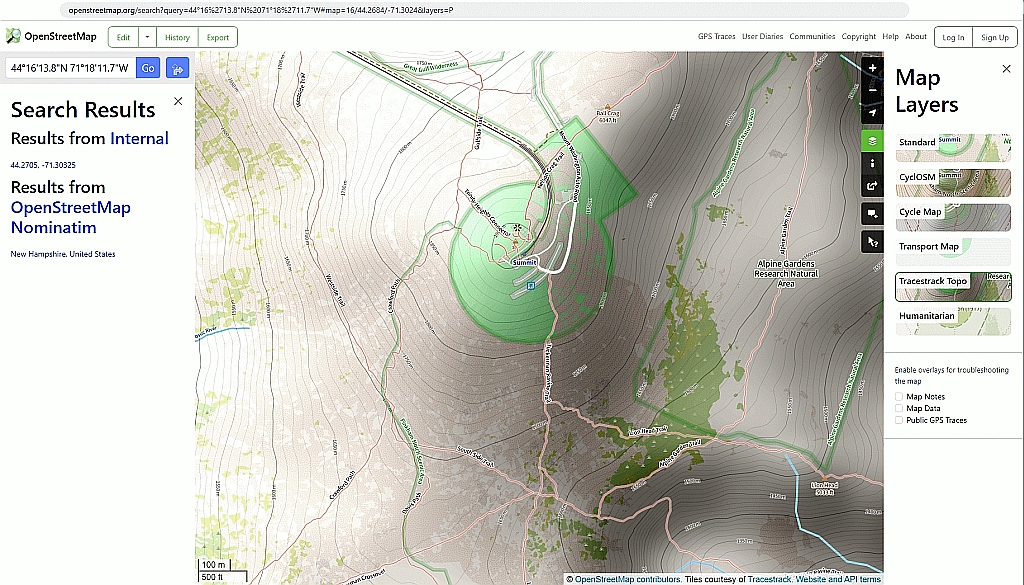
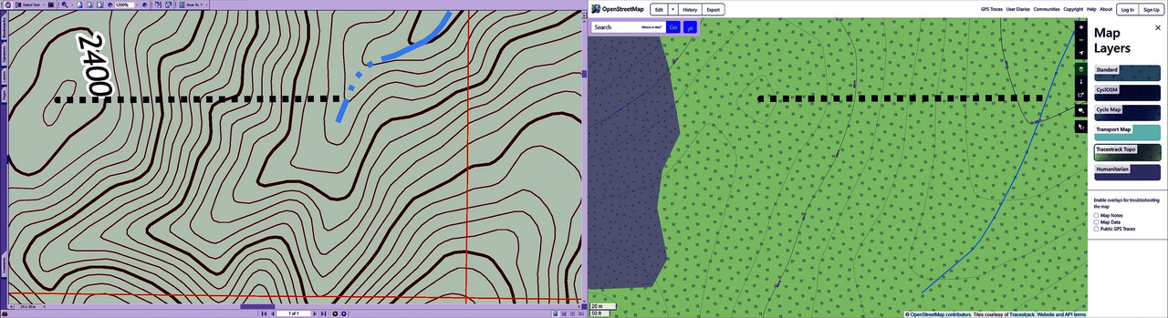
    To help you see the delta, I zoomed into the area I previously provided: https://i.postimg.cc/nV0Ttps6/osm-vs-usgs.jpg

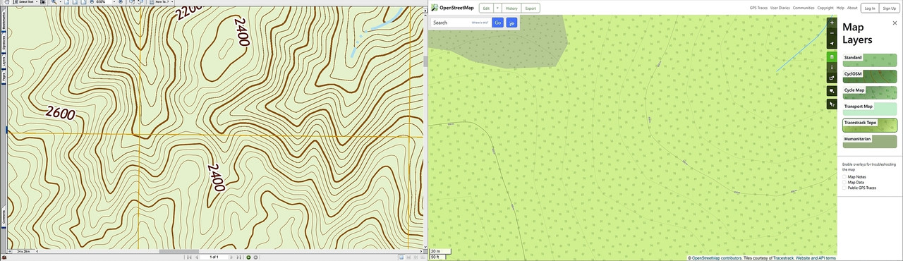
    And then I drew a line of the same size on both maps from two known points. https://i.postimg.cc/bYtQgB42/test1-usgs-vs-osm.jpg

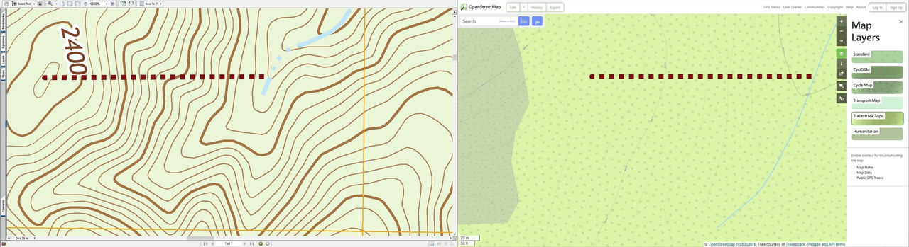
    To help you, I changed HSV values to make the isoclines stand out better. https://i.postimg.cc/4yP4wZGg/test1-usgs-vs-osm-colorized.jpg

    Can you please take a look at those comparisons and let me know if you're
    also seeing the huge discrepancies that I'm seeing in isocline lines?

    Hopefully not from Google as Google's publicly available topo maps are
    horrid in terms of lack of elevation detail.

    Google topography is commercial and therefore cannot be used as a source
    for OSM. (Which needs to be royalty free.)

    Understood. My point was that the Google topography available in their
    normal web page is terrible, although the Google Earth topographic maps are maybe better (they look like USGS maps wrapped around a globe but it has
    been a very long time since I added the USGS maps to Google Earth).

    With "topographic information" you mainly seem to refer to the natural
    part of the topography. And in this mainly contour lines and hydrographic soil data.

    You are correct that I am referring to what I need to know when I'm hiking. Boots on the ground.

    I need to know cliffs. Gullies. Ravines. Gulches. Steep slopes. Hogsbacks. Ridges. Of course roads & structures also are nice to have on those maps.

    The OSM project concentrates on the artificial/cultural aspects of the topography (streets, buildings, names, and the like). To create maps containing natural topographic background information from the geographic
    OSM data, there's some low-res data available. Users and applications
    that need more detailed natural topography include it from other sources.

    That then is probably the reason why OSM topographic maps suck so bad.
    Do you see the difference in the zoomed-in section I showed you above?

    The OSM maps are not only inaccurate but they're missing most great detail.

    Reasoning behind this is concentration on geographic data, that can be
    easily reviewed (and if necessary: corrected) by the participants of the
    OSM project.

    Contour lines, soil and hydrography data and the like are, OTOH, especially suited for a combination of remote sensing and modeling or need inventory
    by specialists (often with tailored equipment and very specific laboratory analyses, for instance for soil and aquiver mapping).

    Contour lines with high resolution, for instance, can be easily calculated from high-res DTM data. If the latter is freely available (nowadays usually from airborne laser scanning with meter or submeter resolution), it is
    just a matter of computing power and/or time to create the former. Here
    in Europe free availability of this data is not a problem. I can't assess
    the availability in the US, though. Shuttle Radar Topography Mission (SRTM) is globally available, but just with resolution of 30 meters, which isn't
    too great.

    Programs like OSMAnd usually combine selected and attributed data excerpts from the central OSM database with contour lines from another source. If
    you get higher resolution contour lines from a better source for your area you can use it to overwrite the standard set. Be aware though, that high-res contour line vector data may require quite some computing power to render on-the-fly.

    For the US, TopOSM may be a good source for OSM based maps with enriched natural topography:
    https://wiki.openstreetmap.org/wiki/TopOSM
    It seems to be an ongoing project, though. So you might be well-advised to confer with them directly.

    Thank you for that information, which is new to me, and which discusses the granularity when they say "Hillshading and contour lines are derived from
    the 1/3 arc-second National Elevation Dataset from USGS." https://www.usgs.gov/search?keywords=Elevation

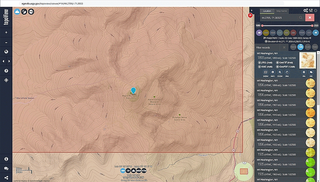
    I generally use the 1:24K maps for backcountry off-road off-trail hiking,
    where I have to look up what it means to be using 1/3 arc-second data. <https://data.usgs.gov/datacatalog/data/USGS:3a81321b-c153-416f-98b7-cc8e5f0e17c3>

    That implies about 10 meter resolution, but I'm not sure how that compares
    to the USGS 1:24000 maps that I habitually load into PaperMaps on Android. https://www.nwcg.gov/course/ffm/mapping/52-map-scale

    I didn't know about that project as I had already long ago given up on the existing OSM topographic maps, but I always wondered why almost all people didn't seem to understand when I said the OSM topo maps are atrocious.

    I think they don't know how great the USA USGS topographic maps are, so
    they don't know enough to assess how terrible the OSM topographic maps are. https://i.postimg.cc/4yP4wZGg/test1-usgs-vs-osm-colorized.jpg

    Looking at the Wiki for TopOSM you referenced, the first thing I noticed is they use the USGS map data, so that's a good sign in terms of accuracy. https://www.usgs.gov/faqs/what-types-elevation-datasets-are-available-what-formats-do-they-come-and-where-can-i-download

    I appreciate you pointed that effort out as it seems the way they differ
    from the source USGS topographic data is they strive to *present* the maps
    in a "more pleasing" way - which is fine by me as

    Unfortunately, when I tried to download the OSM 1/3rd arc-second maps from
    the wiki page referenced, they all came up with a 404 not found error.

    While I'm sure most people follow established trails, I shun them.
    I pick a point on another ridge a mile LOS away and head toward it.

    If this was the case, you'd have no use for a program explicitly created
    for the navigation along artificial lines, like OSMAnd. In the scenario
    you described first, OTOH, you wanted to follow a pre-defined track. (It doesn't matter that this track would be hand-drawn by yourself and would perhaps not follow any real lane or trail.) And you wanted to get routing information whenever you leave this track (too much) or whenever you have
    to take a major turn of direction. If you still want to go this way, but
    find no source for better suited contour lines for your area, you may
    need to use a two-fold approach: Use OSMAnd for navigation commands along your predefined track and use another program for the visualization of
    your current position on (raster) USGS topo maps. If you just rove the
    wild with a rough idea of direction and target, you can forgo navigation completely...

    You are astute in that most of backcountry navigation is dead reckoning,
    but often you're deep in a gully or on your hands and knees in a thicket,
    where dead reckoning is much harder due to lack of farfield visual cues.

    Also just physically staying on a brushy hogsback seems so easy when you
    look at the problem set on a map, but inevitable small errors tend to
    multiply such that you'll be on the wrong side of that hogsback within
    minutes if you're not constantly following the previously drawn track.

    The drawn track is especially important when you're aiming to cross ridges
    at an optimal cleft, since once you aim downhill at the wrong spot, the
    terrain quickly becomes almost impossible to traverse in a matter of feet.

    About the only time you go in a straight line is when you're rappelling.

    Anyway, I appreciate the advice and the new information from you that the
    OSM topographic maps are based on the USGS 1/3rd arc-second USA data.

    May I ask for you to give me advice on two questions that are still open?

    1. Do you see the huge difference that I see in these two zooms?
    https://i.postimg.cc/bYtQgB42/test1-usgs-vs-osm.jpg
    https://i.postimg.cc/4yP4wZGg/test1-usgs-vs-osm-colorized.jpg

    The reason I ask is I hear from everyone how useful the OSM topo maps
    are & yet, when I use them, I find them lacking in almost every way.

    (But I had not known about the 1/3 arc-second OSMTopo maps, which I
    don't have yet - but which I will search to find a source of today.)

    2. Can you help me compare the "granularity" of the OSMTopo
    1/3rd arc-second data versus what I'm currently using, which is the
    1 inch on the map = 24,000 inches on the ground?

    Are they the same?
    Or different?
    Which is more granular?

    Thanks for all your help and advice!

    --- SoupGate-Win32 v1.05
    * Origin: fsxNet Usenet Gateway (21:1/5)
  • From Bernd Rose@21:1/5 to Sten deJoode on Tue Feb 27 23:18:44 2024
    XPost: sci.geo.satellite-nav

    On Tue, 27 Feb 2024 15:56:14 -0500, Sten deJoode wrote:

    I think you don't notice how terrible the OSM topographic maps are because you have nothing better to compare them to outside of the United States.

    Our topographical maps (official as well as OSM) hereabouts are good enough
    to notice few discrepancies in comparison to sub-meter level laserscan DTM. Currently, some of our official (digital) land parcel maps - depicting the ownership of the land - are less accurate when doing in-depth analysis of
    all available sources. Non-essential topographical borders out in the woods
    and fields are usually correct in the sub 5 meter range. That's <0.2 mm on
    your USGS topo map...

    With "topographic information" you mainly seem to refer to the natural
    part of the topography. And in this mainly contour lines and hydrographic
    soil data.

    You are correct that I am referring to what I need to know when I'm hiking. Boots on the ground.

    Walking trails is /also/ "boots on the ground". The trail would be part of
    the OSM vector data, though, because it is either artificially created or
    else identified by someone as relevant for connecting 2 points.

    I need to know cliffs. Gullies. Ravines. Gulches. Steep slopes. Hogsbacks. Ridges. Of course roads & structures also are nice to have on those maps.

    Yes. And if you US citizens would do your homework in the OSM community,
    they would have been included in the OSM data for years. The topographical elements you listed are mappable as (single) objects by the community.
    They do not have the character of contour lines, which are better acquired
    from remote sensing data.

    The OSM project concentrates on the artificial/cultural aspects of the
    topography (streets, buildings, names, and the like). To create maps
    containing natural topographic background information from the geographic
    OSM data, there's some low-res data available. Users and applications
    that need more detailed natural topography include it from other sources.

    That then is probably the reason why OSM topographic maps suck so bad.
    Do you see the difference in the zoomed-in section I showed you above?

    Why should I watch your sorry US-excuse for doing nothing? I will not cross
    the sea just to do your mapping tasks for you.

    Bernd

    --- SoupGate-Win32 v1.05
    * Origin: fsxNet Usenet Gateway (21:1/5)
  • From Sten deJoode@21:1/5 to Bernd Rose on Tue Feb 27 18:43:35 2024
    XPost: sci.geo.satellite-nav

    Bernd Rose wrote:

    On Tue, 27 Feb 2024 15:56:14 -0500, Sten deJoode wrote:

    I think you don't notice how terrible the OSM topographic maps are because >> you have nothing better to compare them to outside of the United States.

    Our topographical maps (official as well as OSM) hereabouts are good enough to notice few discrepancies in comparison to sub-meter level laserscan DTM. Currently, some of our official (digital) land parcel maps - depicting the ownership of the land - are less accurate when doing in-depth analysis of
    all available sources. Non-essential topographical borders out in the woods and fields are usually correct in the sub 5 meter range. That's <0.2 mm on your USGS topo map...

    With "topographic information" you mainly seem to refer to the natural
    part of the topography. And in this mainly contour lines and hydrographic >>> soil data.

    You are correct that I am referring to what I need to know when I'm hiking. >> Boots on the ground.

    Walking trails is /also/ "boots on the ground". The trail would be part of the OSM vector data, though, because it is either artificially created or else identified by someone as relevant for connecting 2 points.

    I need to know cliffs. Gullies. Ravines. Gulches. Steep slopes. Hogsbacks. >> Ridges. Of course roads & structures also are nice to have on those maps.

    Yes. And if you US citizens would do your homework in the OSM community,
    they would have been included in the OSM data for years. The topographical elements you listed are mappable as (single) objects by the community.
    They do not have the character of contour lines, which are better acquired from remote sensing data.

    The OSM project concentrates on the artificial/cultural aspects of the
    topography (streets, buildings, names, and the like). To create maps
    containing natural topographic background information from the geographic >>> OSM data, there's some low-res data available. Users and applications
    that need more detailed natural topography include it from other sources. >>
    That then is probably the reason why OSM topographic maps suck so bad.
    Do you see the difference in the zoomed-in section I showed you above?

    Why should I watch your sorry US-excuse for doing nothing? I will not cross the sea just to do your mapping tasks for you.

    Thanks for that background, where almost every topographic map in the USA
    seems to stem, fundamentally, from the work of the USGS, which has been creating openly available topographic maps of the USA since the 1800s.

    The problem now, is *finding* OSM topographic maps based on that data.

    Even Steve Coast, the OSM founder, said the problem is getting access to
    map data. <https://youtu.be/DE2KvtvFOU4>

    That's the question here, which is to get access to the map data that
    is alluded to in the statement below which was made earlier in the thread.
    "It probably has more to do with discrepancies between visual styles
    of map rendering than with actual wrong or missing items in OSM map
    data."

    The goal is to download those OSM topo maps which are based on the USGS 1/3-arcsecond data as the standard OSM contour line maps aren't adequate. https://wiki.openstreetmap.org/wiki/TopOSM/Details

    The Fermi-paradox question is, where are they?
    I'm trying to find the answer to that question.
    Q: Where can I download USA tiles of reasonable OSM topographic maps?

    It was encouraging when you first had mentioned TopOSM two posts prior.

    Unfortunately I'm on Windows (and Android) while TopOSM only runs on Linux. https://github.com/Ahlzen/TopOSM (toposm.ahlzen.com) https://wiki.openstreetmap.org/wiki/TopOSM

    Googling for lectures by Lars Ahlzen, I found this 1/2 hour YouTube video: https://youtu.be/Fwi-RPtxzEo
    I like that Lars emphasized that a map is worthless without the details.
    And Lars was happy to be getting those details from the USGS elevation NED (1/3") along with USGS NHD & MassGIS data on top of the generic OSM data.

    But every search I run for good 1/3rd arc-second US data, ends up back at
    the USGS such as these links below (none of which are related to OSM maps). https://portal.opentopography.org/datasetMetadata?otCollectionID=OT.012021.4269.1
    https://www.usgs.gov/the-national-map-data-delivery https://www.usgs.gov/3d-elevation-program https://www.sciencebase.gov/catalog/item/627f3792d34e3bef0c9a3191 https://www.sciencebase.gov/catalog/item/4f70a58ce4b058caae3f8ddb https://coast.noaa.gov/dataviewer/#/

    I'm still searching for where those TopOSM contour maps are for the USA.
    Maybe they exist. Maybe they don't exist.

    I don't know yet, but I'm still searching for them.

    --- SoupGate-Win32 v1.05
    * Origin: fsxNet Usenet Gateway (21:1/5)
  • From Harry S Robins@21:1/5 to Sten deJoode on Tue Feb 27 18:00:18 2024
    XPost: sci.geo.satellite-nav

    On Tue, 27 Feb 2024 15:56:14 -0500, Sten deJoode wrote:

    1. Do you see the huge difference that I see in these two zooms?
    https://i.postimg.cc/bYtQgB42/test1-usgs-vs-osm.jpg
    https://i.postimg.cc/4yP4wZGg/test1-usgs-vs-osm-colorized.jpg

    The reason I ask is I hear from everyone how useful the OSM topo maps
    are & yet, when I use them, I find them lacking in almost every way.

    (But I had not known about the 1/3 arc-second OSMTopo maps, which I
    don't have yet - but which I will search to find a source of today.)

    2. Can you help me compare the "granularity" of the OSMTopo
    1/3rd arc-second data versus what I'm currently using, which is the
    1 inch on the map = 24,000 inches on the ground?

    From here
    https://apa.ny.gov/gis/shared/htmlpages/metadata/usgs_250dem.html

    It says the 1-degree USGS Digital Elevation Model [DEM] is also referred to
    as 3-arc-second or 1:250,000 scale DEM data.

    The DEM data for 7.5-minute units correspond to the USGS 1:24,000
    (& 1:25,000) scale topographic quadrangle map series for all the USA.

    There's no mention though of 1/3rd arc second data.
    If it's linear (and it might not be) then 1/3 arc second might be 1:25000?

    --- SoupGate-Win32 v1.05
    * Origin: fsxNet Usenet Gateway (21:1/5)
  • From Terje Mathisen@21:1/5 to All on Wed Feb 28 09:16:57 2024
    XPost: sci.geo.satellite-nav

    If you are looking for the best possible hiking maps, usable on any
    platform, nothing else comes close to the mapant mapping projects
    available in a number of European countries:

    It started with https://mapant.fi/ in Finland, then we processed about
    37 TB of LiDAR data here in Norway and combined that with the official Norwegian Mapping Authority's topo data to create https://mapant.no/
    Please take a look!

    (We have WMTS apis available, I use those on my OsmAnd+ android app, but
    the web interface is also very usable even on phones.)

    Since then we have gotten Spain totally covered (https://mapant.es/),
    they might have the best implementation of all currently, as well as Switzerland (https://www.mapant.ch/ covering both Switzerland and Lichtenstein). Denmark is currently being processed and Sweden is
    waiting on some data access permit.

    Terje

    --
    - <Terje.Mathisen at tmsw.no>
    "almost all programming can be viewed as an exercise in caching"

    --- SoupGate-Win32 v1.05
    * Origin: fsxNet Usenet Gateway (21:1/5)
  • From Bernd Rose@21:1/5 to Sten deJoode on Wed Feb 28 22:02:18 2024
    XPost: sci.geo.satellite-nav

    On Tue, 27th Feb 2024 18:43:35 -0500, Sten deJoode wrote:

    almost every topographic map in the USA
    seems to stem, fundamentally, from the work of the USGS, which has been creating openly available topographic maps of the USA since the 1800s.

    The problem now, is *finding* OSM topographic maps based on that data.

    There's only one worldwide OSM database. (Mirrors, extracts for special purposes or premature data of information contributors aside.) Using the
    right tools, it is possible to combine geographic data from different
    sources, though. And different programs or services may use different
    details, features, ... from the central database when rendering maps
    or just checking out data for later rendering.

    One program, that can combine USGS and OSM data and export the result to
    OsmAnd SQLiteDB or OsmAnd tile formats is the free (and open source)
    Mobile Atlas Creator (MOBAC) - a Java program running on several platforms:

    https://mobac.sourceforge.io/quickstart

    This might be a way to go, if you don't want to wait, until sufficiently detailed OSM maps and contour lines are available for your area.

    Even Steve Coast, the OSM founder, said the problem is getting access to
    map data. <https://youtu.be/DE2KvtvFOU4>

    That's the question here, which is to get access to the map data that
    is alluded to in the statement below which was made earlier in the thread.
    "It probably has more to do with discrepancies between visual styles
    of map rendering than with actual wrong or missing items in OSM map
    data."

    I wrote this, because the OSM rendering of your Mount Washington example
    didn't look too bad. Detailed contour lines would needed to be included
    from a source different than OSM, anyways. But without being rendered
    into the OSM map visualization shown, the OSM database may carry much
    more detail. Take a look at this page:

    https://wiki.openstreetmap.org/wiki/Map_features

    Trails, for instance, can be tagged with different attributes like width, visibility, inclination, difficulty, and more. Deer-hunting stands are
    usually not displayed on maps, but can be captured into the database and rendered, if necessary. Buildings can get height values attached to
    enable later 3D rendering. - This list goes on and on.

    It was encouraging when you first had mentioned TopOSM two posts prior.

    Unfortunately I'm on Windows (and Android) while TopOSM only runs on Linux. https://github.com/Ahlzen/TopOSM (toposm.ahlzen.com)

    The script language (Python) and the programs for the TopOSM map creation process are all available for Windows. But preparation and configuration efforts are not targeted on normal end-users. And the rendering would take quite some time, especially when a lot of zoom levels shall be available.

    Bernd

    --- SoupGate-Win32 v1.05
    * Origin: fsxNet Usenet Gateway (21:1/5)
  • From Bernd Rose@21:1/5 to Harry S Robins on Wed Feb 28 22:17:35 2024
    XPost: sci.geo.satellite-nav

    On Tue, 27th Feb 2024 18:00:18 -0600, Harry S Robins wrote:

    From here
    https://apa.ny.gov/gis/shared/htmlpages/metadata/usgs_250dem.html

    It says the 1-degree USGS Digital Elevation Model [DEM] is also referred to as 3-arc-second or 1:250,000 scale DEM data.

    The DEM data for 7.5-minute units correspond to the USGS 1:24,000
    (& 1:25,000) scale topographic quadrangle map series for all the USA.

    There's no mention though of 1/3rd arc second data.
    If it's linear (and it might not be) then 1/3 arc second might be 1:25000?

    That's just a discussion of packaging units. Rasterized contour lines can
    take up quite some space. To use this DEM data in combination with other topographic information, different levels of detail are linked to standard
    map tiling systems. (And their boundaries are /usually/ clipped to round coordinates of the underlying coordinate system: round degree/minute/second values for geographic coordinate systems; fixed meter/yard/whatever values
    for projected coordinate systems.)

    The level of detail for each contour line as well as the altitude classes depicted by separate lines will be adjusted to the typical zoom level of
    each tile. This way, small scale maps do not only compress better (and can therefore be larger and cover more area with the same amount of data when compared to smaller, but more detailed large scale maps. More importantly,
    the readability of the map increases due to the reduced data, when viewed
    with small map scales (aka zoomed out).

    Bernd

    --- SoupGate-Win32 v1.05
    * Origin: fsxNet Usenet Gateway (21:1/5)
  • From Sten deJoode@21:1/5 to Bernd Rose on Thu Feb 29 01:49:16 2024
    XPost: sci.geo.satellite-nav

    On Wed, 28 Feb 2024 22:02:18 +0100, Bernd Rose wrote:

    One program, that can combine USGS and OSM data and export the result to OsmAnd SQLiteDB or OsmAnd tile formats is the free (and open source)
    Mobile Atlas Creator (MOBAC) - a Java program running on several platforms: https://mobac.sourceforge.io/quickstart
    This might be a way to go, if you don't want to wait, until sufficiently detailed OSM maps and contour lines are available for your area.

    Thanks for all your help, which I very much appreciate since you're worlds ahead of me on using georeferenced map tiles on the device for navigation.

    I'm somewhat familiar with georeferencing (eg with oziexplorer & QGis),
    so I thank you for letting me know about Mobac, which I had never heard of.

    https://sourceforge.net/projects/mobac/
    This application creates off-line atlases of raster maps for various cell
    phone apps on Android, iPhone and WindowsCE as well as GPS devices (Garmin, Magellan and others)
    Features
    Download map tiles from various online maps
    Create maps and atlases for your favorite mobile navigation program https://mobac.sourceforge.io/quickstart
    https://mobac.sourceforge.io/ https://sourceforge.net/projects/mobac/postdownload https://psychz.dl.sourceforge.net/project/mobac/Mobile%20Atlas%20Creator/MOBAC%202.0/Mobile%20Atlas%20Creator%202.3.3.zip
    Name: Mobile Atlas Creator 2.3.3.zip
    Size: 17200240 bytes (16 MiB)
    SHA256: D0481AA5E0268C3CFAA68B962E614F6BD5E67FF18ABA202426097C822A173DE0
    unzip
    Name: Mobile Atlas Creator.exe
    Size: 78336 bytes (76 KiB)
    SHA256: 5C1A58F5C92E4FD280AAB877F3EC5ADD5DC4852E17A7B4473195394C408E0C4D

    "It probably has more to do with discrepancies between visual styles
    of map rendering than with actual wrong or missing items in OSM map
    data."

    I wrote this, because the OSM rendering of your Mount Washington example didn't look too bad.

    I agree. The Mount Washington detail in OSM maps surprised even me.
    But the *local* OSM contour map detail is so bad as to be almost unusable. https://i.postimg.cc/4yP4wZGg/test1-usgs-vs-osm-colorized.jpg

    I love the idea of OSM and I "hear" people telling me all the time how
    great the contour maps are, but I've used them along with USGS maps.

    The point is I hear well but I see better. What I want is to see what other people appear to be saying they're seeing - because I'm not seeing it. Yet.

    Detailed contour lines would needed to be included
    from a source different than OSM, anyways. But without being rendered
    into the OSM map visualization shown, the OSM database may carry much
    more detail. Take a look at this page: https://wiki.openstreetmap.org/wiki/Map_features

    From that, mainly I care about OSM elevation (ele) information. https://wiki.openstreetmap.org/wiki/Key:ele

    And Altitude.
    https://wiki.openstreetmap.org/wiki/Altitude

    Which says: "elevation is just an "afterthought" stored in the tag system
    under the ele=* and its subkeys"

    Trails, for instance, can be tagged with different attributes like width, visibility, inclination, difficulty, and more. Deer-hunting stands are usually not displayed on maps, but can be captured into the database and rendered, if necessary. Buildings can get height values attached to
    enable later 3D rendering. - This list goes on and on.

    I only care about elevation as once there's a trail, you don't a map
    (as much as you need that map when they're no trail at all to follow).

    The whole point of accurate contours is to be able to pick a hogsback and
    stay on it to get from point A to point B on another ridge a mile away.

    Once you fall off the hogsback, your entire hike is doomed as you can't get
    out of these ravines on terms other than the rule of the ravine, which is always that you'll end up at a stream and then finally at a lake.

    Almost always miles away from where you had intended on going by staying
    out of the ridges and only on the hogsback (on all fours most of the time).

    Every few minutes you pull your phone out of your pocket to see if you're
    still on the ridge as you can barely tell the isocline lines while on all
    fours and with visibility being essentially what a rabbit sees all day.

    It was encouraging when you first had mentioned TopOSM two posts prior.

    Unfortunately I'm on Windows (and Android) while TopOSM only runs on Linux. >> https://github.com/Ahlzen/TopOSM (toposm.ahlzen.com)

    The script language (Python) and the programs for the TopOSM map creation process are all available for Windows. But preparation and configuration efforts are not targeted on normal end-users. And the rendering would take quite some time, especially when a lot of zoom levels shall be available.

    Thanks for that advice. My PC is old, from 2010, so it's not likely beefy enough - but it works well with the USGS topographic maps as does loading
    the USGS georeferenced PDFs into Avenza or into PaperMaps.
    <https://www.avenza.com/avenza-maps/>
    <https://play.google.com/store/apps/details?id=com.Avenza>
    <https://apps.apple.com/app/apple-store/id388424049>

    <https://www.paper-maps.com/>
    <https://play.google.com/store/apps/details?id=ca.abbro.androidmap>
    <https://apps.apple.com/app/nextmap/id1147385120>

    In my opinion, Avenza is better, but the free version is artificially
    limited to three map tiles (although you can combine georeferenced PDFs so
    it's only a matter of extra effort with QGis or OziExplorer to do that).

    Thanks for all your help, which I very much appreciate, as I'm a novice.

    --- SoupGate-Win32 v1.05
    * Origin: fsxNet Usenet Gateway (21:1/5)
  • From Bernd Rose@21:1/5 to Sten deJoode on Thu Feb 29 21:29:50 2024
    XPost: sci.geo.satellite-nav

    On Thu, 29th Feb 2024 01:49:16 -0500, Sten deJoode wrote:

    I agree. The Mount Washington detail in OSM maps surprised even me.
    But the *local* OSM contour map detail is so bad as to be almost unusable.

    You still mix displayed maps with data. /All/ maps displaying contour lines will /not/ have OSM as basis for the contour lines; even if they show up
    under the label "OSM". The OSM database only carries data for /discrete/ geographic *objects*. Contour lines, OTOH, are a (somewhat arbitrary) classification of /continuous/ earth surface heights.

    Contour lines can neither be mapped nor evaluated by individuals on-terrain. Historically, sophisticated (and time-consuming triangulation was necessary
    to get the data to create a more-or-less accurate height representation of
    the earth surface. Nowadays, the creation of contour lines usually is a geostatistical derivation from remote sensing data.

    Different usage scenarios and different zoom levels require other density
    (= height classification ranks) and generalization (= smoothing of small
    height variations) levels. To cover all possibilities, the OSM database
    would probably double or triple in size. Therefore, everybody who wants
    to create a map from OSM /with/ contour lines has to find a suitable
    source and pick (one or more) set(s) of contour lines from this source,
    if different levels of density and generalization are available.

    Detailed contour lines would needed to be included
    from a source different than OSM, anyways. But without being rendered
    into the OSM map visualization shown, the OSM database may carry much
    more detail. Take a look at this page:
    https://wiki.openstreetmap.org/wiki/Map_features

    From that, mainly I care about OSM elevation (ele) information. https://wiki.openstreetmap.org/wiki/Key:ele

    This (optional) tag has /nothing/ to do with contour lines. It is a means
    to associate height values to geographical OSM *objects*, like buildings, swamps, or sections of a road or trail.

    [TopOSM scripts]
    The script language (Python) and the programs for the TopOSM map creation
    process are all available for Windows. But preparation and configuration
    efforts are not targeted on normal end-users. And the rendering would take >> quite some time, especially when a lot of zoom levels shall be available.

    Thanks for that advice. My PC is old, from 2010, so it's not likely beefy enough - but it works well with the USGS topographic maps as does loading
    the USGS georeferenced PDFs into Avenza or into PaperMaps.

    Huh?? The TopOSM scripts render map tiles to look comparable to USGS topo tiles. Once they are rendered, they should not take other computing power
    for display than USGS topo tiles. What's time and resource consuming is the process of rendering the tiles for different zoom levels (with different
    levels of detail shown), itself. Information from a couple of different
    sources (OSM geographical objects being just one source; elevation and hydrography are included from USGS data sources) needs to be downloaded, recomputed and combined for several zoom levels.

    Bernd

    --- SoupGate-Win32 v1.05
    * Origin: fsxNet Usenet Gateway (21:1/5)